|
||

|

|
|

|
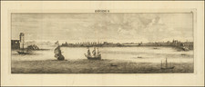
Nice old color example of Braun & Hogenberg's views of Candia and Corfu. Two images on one sheet depict the cities with a focus on the port area. Ships typical of the region are illustrated, some under sail while others are engaged in an activity like fishing. Vivid hand coloring provides a nice perspective into the scenery of these Ionian islands.
The first image shows the area of Candia, more commonly known now as Crete. As an island in the middle of the Ionian Sea, Candia was a major stopover for trade in the region. As such, the image shows a prosperous, fortified port city with many ships docked or surrounding the area. Candia was also controlled by Venice so the mercantile nature of the island was further underscored.
The second image is an overview of Corfu, another Venetian-controlled island in the Ionian Sea. The image provides a colorful glimpse of the city, port, and trading town of Corfu. Looking closely, the Castell Nouo flies what appears to be the war flag of Venice. Ships typical of the region can be seen plying the waters and docked in port. Smoke comes out of the cannons in the fortress and on some of the ships. Inside the town are nicely arranged neighborhoods and the churches of Saint Frances and Saint Lazaro.
Georg Braun (1541-1622) was born and died in Cologne. His primary vocation was as Catholic cleric; he spent thirty-seven years as canon and dean at the church St. Maria ad Gradus, in Cologne. Braun was the chief editor of the Civitates orbis terrarum, the greatest book of town views ever published. His job entailed hiring artists, acquiring source material for the maps and views, and writing the text. In this role, he was assisted by Abraham Ortelius. Braun lived into his 80s, and he was the only member of the original team to witness the publication of the sixth volume in 1617.
Frans Hogenberg (ca. 1540-ca. 1590) was a Flemish and German engraver and mapmaker who also painted. He was born in Mechelen, south of Antwerp, the son of wood engraver and etcher Nicolas Hogenberg. Together with his father, brother (Remigius), uncle, and cousins, Frans was one member of a prominent artistic family in the Netherlands.
During the 1550s, Frans worked in Antwerp with the famous mapmaker Abraham Ortelius. There, he engraved the maps for Ortelius’ groundbreaking first atlas, published in Antwerp in 1570, along with Johannes van Deotecum and Ambrosius and Ferdinand Arsenius. It is suspected he engraved the title page as well. Later, Ortelius supported Hogenberg with information for a different project, the Civitates orbis terrarium (edited by Georg Braun, engraved by Hogenberg, published in six volumes, Cologne, 1572-1617). Hogenberg engraved the majority of the work’s 546 prospects and views.
It is possible that Frans spent some time in England while fleeing from religious persecution, but he was living and working in Cologne by 1580. That is the city where he died around 1590. In addition to his maps, he is known for his historical allegories and portraits. His brother, Remigius, also went on to some fame as an engraver, and he died around the same time as his brother.
![[ Ancient Greece & Balkans ] Illyricum, Dacia, Moesia Macedonia et Thracia](https://storage.googleapis.com/raremaps/img/small/102174.jpg)