


|
||

|

|
|

|
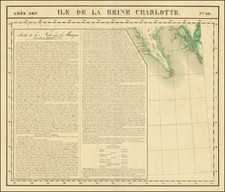
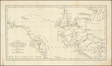
Hand Drawn American Chart of Kodiak Island Drawn During The 1867 Davidson Expedition
The present map is a finely crafted hand drawn chart of the northeastern part of Kodiak Island on drafting linen, which includes the tracks of a ship's visit to Kodiak Island and apparently several side excursions. Internal and historical evidence strongly indicates that this was one of the maps drawn during George Davidson's expedition to Alaska in the summer of 1867, undertaken as part of the United States's formal taking of possession and first reconnaissance of Alaska, following its acquisition from Russia.
The map illustrates the tracks of a voyage to and from St. Paul (now Old Harbor), on Kodiak Island, Alaska, with evidence of several side excursions along the east coast of the island. While unsigned and undated, the map is almost certainly an original map created on the first American expedition to Kodiak Island in 1867, led by famed American mapmaker and historian George Davidson.
The map shows the northeastern part of Kodiak Island with a small inset of St. Paul's Harbor and its entrance illustrated. The map features hand-drawn depictions of the general area including Popoffsky Bay and the Island of Sialchlidacc. Smaller insets feature a nice illustration of St. Paul's Harbor and the route into the bay. These include what appears to be sounding depths to help ships not run aground.
To the right in very light pencil is an elaborate compass drawing.
The map is based in large part on a rare 1852 Russian map of Nova Archangel by Mikhail Dmitrievich Tebenkov, with a number of minor changes and updates.
George Davidson in Alaska
George Davidson was chosen to lead an expedition to Alaska in 1867, shortly after the ratification of the purchase of Alaska by the United States in 1867. The expedition was more than simply a first look at American Alaska. William Seward, who had negotiated the purchase of Alaska from the Russians, had apparently done so in relative secrecy, so much so, that while the acquisition treaty had been ratified by the U.S. Senate, there was significant doubt as to whether the House of Representatives would approve the necessary appropriations for payment of the $7,200,000 purchase price.
Davidson sailed aboard the Revenue Cutter Lincoln from San Francisco to Alaska on July 21, 1867. After a brief stay in Victoria, British Columbia, the expedition proceeded north to Sitka, arriving on August 12. After a 10 day stay in Sitka, Lincoln proceeded to Kodiak Island, arriving on August 26, 1867.
As noted by FitzGerald,
In the summer of 1867, George Davidson and others made an extensive cruise of Alaskan waters in the Revenue Cutter Lincoln, and as a result prepared cruise charts of Sitka Harbor, Saint Paul Harbor, Kodiak Island, and Captain's Bay on Unalaska Island. The first two Coast Pilots of Alaska were published betweeri 1869 and 1883, based on the work of George Davidson, William H. Dall, and Marcus Baker.
As noted by Sherwood,
When Davidson returned to Washington, he conferred with Seward, McCulloch, and Sumner, appeared before House and Senate Committees, and read a paper on Alaska before the National Academy of Sciences. There is a common belief that his activities and report influenced the passage of the purchase appropriation bill in the House. Davidson himself did not exactly discourage the belief. In a manuscript Autobiography submitted to Alonzo Phelps, in 1879, a section to this effect is crossed out. But later in the century, Davidson wrote:
the report found defenders on the floor of the House, as it had certainly done in the committees. Its statements were never traversed but were used on every occasion, and I was assured that this report and my conferences had large weight in the passage of the bill appropriating the money.
The present manuscript map is a remarkable artifact of the first ever American expedition to Alaska.
Rarity
The map is a unique survival, which likely influenced the maps of Alaska published by the Coast Survey in 1869.
Morgan B. Sherwood: Pacific Historical Review , May, 1959, Vol. 28, No. 2, pp. 141-154 (May, 1959).
George Davidson (1825-1911), was one of the most important mapmakers and scientific minds of the 19th Century.
Davidson was born in England and moved to the US in 1832. He met Alexander D. Bache in 1842, when he assisted Bache in his observations of the magnetic elements at Girard College. Upon his graduation in 1845, he began his career as clerk to Bache who was superindentent of the United States Coast Survey.
From 1846 to 1850, Davidson was occupied in geodetic field work and astronomy on the east coast. In 1850, he went to California, where he was engaged in the determination of the latitude and longitude of prominent capes, bays, etc., and of the magnetic elements of the Pacific Coast, including a survey of Washington and Puget sounds, and the main triangulation of the coast in the region of San Francisco.
From 1861 to 1867, he was again on the Atlantic seaboard, principally engaged in engineering work on coast and river defences. In 1866, he became chief engineer of an expedition for the survey of a ship canal across the Isthmus of Darien.
In 1867, he was appointed to make a special examination and report upon the geography and resources of Alaska, pending its purchase; his published report and conferences with congressional committees influenced the passage of the bill. He was placed in charge, during 1867, of the work of the Coast Survey on the Pacific, planned work for the land parties from 1868 until 1875, and inspected all the fields of work.
From 1876 to 1886, he had charge of the main triangulation and astronomical work on the west coast; the records of the computing division showed that the results of his observations stood higher than any ever executed in America, Europe, or India, and they were characterized as “unique in the history of geodesy.
In 1881, Davidson twice measured the Yolo base line, one of the geodesic base lines that formed the foundation of triangulating distances in California. At that time, it was the longest base line yet attempted in trigonometrical operations, and the system of triangulation directly connected therewith was called in his honor the “Davidson quadrilaterals.” He also measured the Los Angeles base line three times in 1888-1889. He retired from the Coast Survey in 1895, after 50 years of service.
Davidson also founded the Davidson Observatory in San Francisco, which was the first astronomical observatory on the Pacific coast of North America, and in 1869 brought the Pacific geodetic of the coast survey in telegraphic longitude connection with Greenwich. His astronomical work includes the observation of the total solar eclipse under the 60th parallel, in 1869; determination of the 120th meridian in 1873; charge of the U. S. transit of Venus expedition, in 1874; recovery of the transit of Venus station of 1709 in Lower California occupied by Auteroche de la Chappe; observation of the total solar eclipse of January 7, 1880; and in 1882 charge of the party to observe the transit of Venus in New Mexico.
Other positions held by Davidson include president of the California Academy of Sciences from 1871 to 1887, Honorary Professor of Geodesy and Astronomy, and Regent of the University of California from 1877 to 1885. After his retirement from the Coast Survey,[4] he became the first professor of geography at the University of California, Berkeley, and chaired that department from 1898 until his retirement in 1905, and remained an emeritus professor until his death. Davidson was one of 182 charter members of the Sierra Club in 1892 and served as a member of its board of directors from 1894 to 1910.
![[Russian Alaska] Меркаторская Генеральная Карта, части Российскихъ Владеній въ Америкѣ (Mercator's [or Mercatorial] General Map, parts of Russian Possessions in America)](https://storage.googleapis.com/raremaps/img/small/55959.jpg)