|
||

|

|
|

|
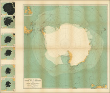
Mapping The Aurora Borealis -- Hermann Fritz and Data Visualization
Interesting representation of the Northern Hemisphere, based upon the cartographic work of Hermann Fritz, showing the geographic distribution of the aurora borealis, published at the scale of 1:70,000,000.
Hermann Fritz was a significant figure in the field of geophysics during the 19th century, known for his contributions to understanding the aurora borealis. Fritz's work involved the systematic study of the occurrences and distributions of the Northern Lights, culminating in the creation of maps that provided a visual representation of these phenomena across the Northern Hemisphere.
His studies were instrumental in advancing the field of auroral research, which was of keen interest during the period due to the broader implications for understanding the Earth's magnetosphere and its interactions with solar winds. Through his meticulous compilation of observational data, Fritz sought to discern patterns and frequencies in the appearances of the aurora borealis, thus contributing to the scientific community's ability to predict and explain these natural occurrences.
Fritz's work reflects the 19th-century enthusiasm for discovering the underlying laws governing natural phenomena and the drive to document and understand the world's many mysteries, including the elusive and beautiful aurora borealis. The map transcends mere geographic boundaries, inviting viewers into a realm where science and artistry converge.
The cartographic techniques employed in the map are indicative of the era's scientific endeavors. Isochrones and lines denoting the frequency of visibility of the aurora borealis are intricately drawn, converging upon the polar regions in a symphony of scientific observation and graphic representation.
August Heinrich Petermann (1822-1878) is a renowned German cartographer of the nineteenth century. Petermann studied cartography at the Geographical Art-School in Potsdam before traveling to Edinburgh to work with Dr. A. Keith Johnston on an English edition of Berghaus’ Physical Atlas. Two years later he moved to London, where he made maps and advised exploratory expeditions as they set off to explore the interior of Africa and the Arctic.
In 1854, Petermann returned to Germany to be Director of the Geographical Institute of Justus Perthes in Gotha. There, he was the editor of the Geographische Mittheilungen and Stieler’s Handatlas. The Royal Geographical Society of London awarded him their Gold Medal in 1860. He continued his interest in exploration in Germany, fundraising for the German Exploring Expeditions of 1868 and 1869-70, which sought an open Arctic sea. Tragically, he committed suicide in 1878.
![[ Charting Hall's Quest For The North Pole ] Die Entdeckungen der Amerikanischen Nordpolar-Expedition unter Kapitan C.F. Hall 1871-1873. Reduction der vom Hydrographic Office, U.S. Navy harausgegebenen grossen Karte.](https://storage.googleapis.com/raremaps/img/small/98478.jpg)
![[English Edition!] Maris Pacifici quod vulgo Mar del Zud](https://storage.googleapis.com/raremaps/img/small/71000.jpg)