|
||

|

|
|

|
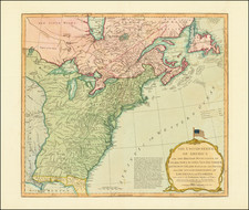
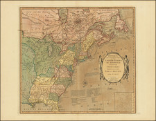
American Expansion and New Territorial Boundaries On the Eve of the War of 1812
Fascinating map of the United States, published shortly before the publication of the official account of Lewis & Clark's expedition to the source of the Missouri River and on to the Pacific.
East of the Mississippi, the map includes several ephemeral US Territories, including New Orleans Territory (which existed from October 1, 1804, until April 30, 1812), Mississippi Territory (pre-dating Alabama) and a massive Northwest Territory (including all of Michigan, Indiana, Illinois, Wisconsin and most of Minnesota.
East Florida and West Florida (Floride Occidentale and Floride Orientale) are shown. This is during the period of the short lived Republic of West Florida (1810), shortly before it was annexed by Florida in 1812.
The map is also noteworthy for its treatment of the newly acquired Louisiana Territory, with the Missouri, Kansas, Osage and other rivers shown, along with the Mississippi River reaching speculatively toward the Lake of the Woods, with a number of Indian Tribes shown.
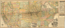
![Colton's United States Shewing Military Stations, Forts &c. . . . 1861 [Shows Colorada!]](https://storage.googleapis.com/raremaps/img/small/95088.jpg)