|
||

|

|
|

|
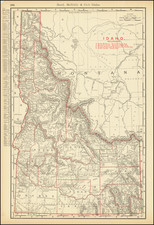
Early Forestry and Conservation Map of Idaho
Survey of the beautiful St. Joe National Forest, Idaho, and surrounding areas. This map mainly features the 867,882 acres of land that make up the National Forest. St. Joe National Forest is well known for its history of timber industry and tourism which the map reflects through the inclusion of areas beyond the scope of the park. Note the illustrious area of southern Couer D'Alene and Lake Couer D'Alene in the north as well as the popular Clearwater National Forest to the east. These locations make up the Idaho Panhandle National Forest, a popular location for recreation and natural industry.
An intriguing example of early forestry work done by the United States Forestry Service. This map was made with survey information gathered by W.B. Greely, the third chief of the Forestry Service. Done only twenty years after the inception of the Forestry Service, this map showcases the growing struggle between conservation and industry that the government grappled with throughout the 20th century.
The map was designed for use in an administrative capacity. The intricate details regarding topography, waterways, forests, and logging camps are useful to determine the viability of development in the region. For example, the map illustrates major and minor waterways of the region, which were vital for transportation and logging activities during this period. Furthermore, the clear demarcation of county and park boundary lines indicates the geographic scope and jurisdiction of the area, which would have been critical for governmental and conservation-related considerations. All these features indicate the purposes this map could be used for as people began to increasingly develop and exploit the natural resources of the country during the 1920s.
This map employs a polyconic projection, a popular technique for land surveys in the early 20th century. The technique allows one to represent a large portion of the Earth's surface with relatively low distortion, especially near the central meridian. Its properties make it suitable for regions that have a greater east-west extent, such as the United States. Although this methodology would decline in popularity, this map is a fine example of a mostly forgotten technique.
Manuscript Additions
Note the hand-drawn portion of the map as it conveys this area is of particular importance. The drawn symbols may represent certain facilities either in the area or that could be built, while those dates suggest the last time the area was properly examined. Greely, the maker of this map, was chiefly concerned with the relationship between industry and conservation. As such, he sought to develop a policy that would enable logging while also keeping a forest healthy. This map represents Greely's ideals as he attempted to strike a balance between man and nature in St. Joe's National Forest.
![[ Sun Valley Ski Map ]](https://storage.googleapis.com/raremaps/img/small/101431.jpg)