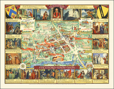
|
||

|

|
|

|
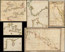
Rare working navigational sea chart, published in London by J.S. Hobbs.
Hobbs chart is an exceptional representation of maritime cartography that integrates an array of navigational features. The chart extensively covers the English Channel, the Bristol Channel, and the contiguous coasts of Southern Ireland, Southern England, as well as a portion of the coast of France.
One of the chart's most noteworthy elements is the inclusion of hundreds of soundings, providing crucial underwater topographic data. Complementing this are profile views of land elevations and lighthouses, which act as indispensable visual aids for maritime navigation, particularly when approaching coastlines or navigating through tricky channels.
The chart is further enriched by inset maps of key harbors such as Dartmouth, Plymouth, the Isle of Wight and vicinity, the Downs and Margate Roads, Torbay, and Falmouth. These insets provide localized detail, making the chart a comprehensive navigational tool for both wide-ranging and localized maritime activities. Moreover, the inclusion of extensive sailing instructions and other navigational aids reveals the chart's commitment to the practical needs of seafarers in the mid-19th century.
Altogether, the chart embodies a blend of scientific precision and functional utility, reflecting the maritime challenges and technological capabilities of its era. It stands as an invaluable resource for understanding the complex waterways it depicts, showcasing the state of maritime cartography in the 1860s.
![[ United Kingdom ] Tabula Prima Europae](https://storage.googleapis.com/raremaps/img/small/78537.jpg)
![[ British Islands ] Wight / Scilly / Jersey / Guernsey / Alderney / Man / Holy / Farne ] The Smaller Islands in the British Ocean](https://storage.googleapis.com/raremaps/img/small/98973.jpg)