


|
||

|

|
|

|
The First Scientific Charting Guanabara Bay / Rio de Janeiro
Rare and important chart of Guanabara Bay, based upon the work of the Jesuit mapmaker Domenico Capacci.
The "Plan de la Baye et Port de Rio Janeiro Situee a la Coste du Bresil" from 1785 is a detailed representation of the Rio de Janeiro bay area. This sea chart, derived from Domenico Capacci's manuscript chart of Guanabara Bay, carefully outlines the bay, its neighboring islands, topographical features of the coastline, soundings, lagoons, anchorages, river mouths, and even a town grid for Rio Janeiro. Such precision is a testament to Capacci's skills and methodical approach to cartography.
Domenico Capacci in Brazil
Born in Naples in 1694, Domenico Capacci was a Jesuit priest known for his expertise in astronomy and cartography. His significant contribution in Brazil began when he, along with Diogo Soares, arrived in Rio de Janeiro in 1730, commissioned by João V of Portugal to advance the region's cartographic understanding, especially given the economic importance of Brazil's gold and diamond discoveries.
Their first major task in Brazil was setting up an astronomical observatory on the morro do Castelo. The aim was to determine the Rio de Janeiro meridian, which was crucial for accurate map-making in the region. From 1732 to 1735, the duo worked on maps detailing regions from the gold mines in southern Minas Gerais to the Serro Frio diamond mines in the north. Their work culminated in 1737 with the mapping of the main ports in the Capitania of São Pedro do Rio Grande do Sul.
Capacci's time in Brazil, though brief, was impactful. His precise approach to cartography, as evident in the 1785 sea chart, reflects his commitment to advancing the field during his tenure in Brazil.
Jean-Claude Dezauche (fl. 1780-1838) was a French map publisher. Initially, his work focused on engraving music, but he later turned primarily to cartography. His is best known for editing and reissuing the maps of Guilluame De L’Isle and Philippe Buache, two of the most skilled mapmakers of the eighteenth century. He acquired the plates of these two men’s work in 1780 from Buache’s heir, Jean-Nicolas Buache. Dezauche's business received a further boon when he received a privilege to sell the charts of the Dépôt de la Marine. His business was carried on by his son, Jean-Andre Dezauche.
![[San Salvador / Bahia] Carte Reduite De La Baie De Todos os Santos Et De Ses Atterages Situes a la Cote du Bresil Leve in 1819 dans la Campagne de la Corvette la Bayadere et du Brick le Favory par M.M. Givery et Gressier . . . . . . 1823](https://storage.googleapis.com/raremaps/img/small/62801.jpg)
![[ Rio de Janeiro / Guanabara Bay ] Plan de la Baye et Port de Rio Janeiro Situee a la Cost due Bresil . . . Levee Geometriquement par le P. Capassi . . . 1785](https://storage.googleapis.com/raremaps/img/small/97782.jpg)
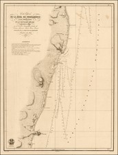
![[Ilha da Santa Catarina to Bombinhas]](https://storage.googleapis.com/raremaps/img/small/59595.jpg)