|
||

|

|
|

|
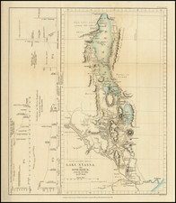
Early Colonial Exploration of East Africa
An excellent map detailing the expeditions of Sir Alfred Sharpe as presented to the Royal Geographical Society. Sharpe and his map would be instrumental in tightening British control over the region by allowing for easier navigation.
The map illustrates the route of Sharpe from Lake Nyassa (today called Lake Malawi) across the interior of East Africa. These expeditions created a solid route for British colonists to access the region from the sea. Lake Nyassa connects to the Indian Ocean via a tributary river, allowing for easier interior navigation. Note the 1890s expedition that entered the region through Leopard Bay in the Indian Ocean.
A unique facet of this map is its inclusion of informative notes on the geographical characteristics and survivability of the areas the expedition traveled. Sharpe lists possible areas for colonization, such as calling Pakalimapua "pleasant country" with ample water and good soil or noting the possibility of Alluvial Gold in Missala. Sharpe also notes the inhospitable locations the expedition traveled through, such as a 65-mile stretch without any water between Muasi and Wiese or an abundance of tsetse fly throughout Pakaundi. The inclusion of these notes indicates Sharpe's desire to develop the area for British colonization by helping future explorers and settlers navigate the area.
![IX. b [East Africa]](https://storage.googleapis.com/raremaps/img/small/93300.jpg)