


|
||

|

|
|

|
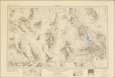
Illustrating All of the Street Corners in Winslow, Arizona.
Winslow Navajo County Ariz, produced by the Sanborn Map Company in 1927, provides a detailed representation of the city, with particular emphasis on its fire prevention systems, water facilities, and prevailing architectural structures. Updated in July 1931, this nine-sheet fire insurance atlas offers a systematic account of the township's infrastructure, focusing especially on its water supply sourced from Clear Creek and the functionalities of its volunteer fire department.
In the 1920s, Winslow stood as a significant hub in the American Southwest. With the Santa Fe Railroad establishing the town as a major stopover point, Winslow quickly became a bustling center of trade, transportation, and opportunity. Its strategic location meant that goods, cultures, and ideas frequently passed through, adding layers to its multicultural tapestry. As with many towns during the Roaring Twenties, Winslow saw economic prosperity, cultural shifts, and architectural growth. The 1920s also brought the rise of automobile travel, with Route 66 cutting a path close by, further cementing Winslow's position as a crucial nexus between the eastern and western United States.
The atlas employs a range of symbols to represent distinct building materials—brick, stone, and wood among others—and offers specifics on architectural elements, such as the heights of fire walls and the positions of steam boilers.
Of notable mention is the atlas's extensive detailing of Winslow's water facilities, managed by the Santa Fe Improvement Co. The town's water infrastructure incorporates various elements, from electric turbine pumps manufactured by Byron Jackson & Johnson to a large reservoir system. This water infrastructure is intertwined with the resources of the volunteer fire department, which is equipped with an assortment of apparatuses including the American La France Pumper.
An inset of the front page focuses on the operations of the Atchison, Topeka & Santa Fe Railroad Company's ice plant, revealing its operational capabilities, the employment of a diesel engine, and its daily ice production capacity.
Rarity
The Winslow, Arizona Sanborn Atlas is very rare in the market. Not a single example of any edition is located in OCLC, though California State Northridge lists a 1927 edition in the index to their large Sanborn Atlas collection and the Library of Congress has digitized a 1927 edition, but the latter does not incorporate the numerous corrections through July 1931 included on our example.
The Sanborn Map Company, founded in the 1860s by Daniel Alfred Sanborn, is a renowned cartographic institution primarily recognized for its unparalleled fire insurance atlases. These atlases emerged as indispensable tools during the late 19th and early 20th centuries, portraying the evolution of urban America with unprecedented detail and precision. Charting both burgeoning metropolises and smaller municipalities, Sanborn's fire insurance maps provide a unique and illuminating perspective on the physical, economic, and social transformation of the nation during a period of intense urbanization and industrialization.
During the latter half of the 19th century, the United States witnessed an acceleration in urban growth. This shift from rural to urban living, bolstered by the advent of the Industrial Revolution, generated densely populated areas with a diverse array of architectural styles, materials, and infrastructure. In this context, the need for comprehensive maps that could illustrate the specifics of the built urban fabric became paramount, especially for insurance companies seeking to assess the risks associated with insuring individual properties. The Sanborn Map Company responded to this demand, creating elaborate maps that identified building materials, the purpose of structures, and even features like fire walls and sprinkler systems.
A standout feature of Sanborn's maps was their color-coding system, which allowed for a swift and clear differentiation between building materials—whether wood, brick, iron, or otherwise. This system, paired with the company's legends -- detailing everything from the width of streets to the locations of hydrants -- made these atlases an invaluable resource for insurance underwriters. By the turn of the 20th century, Sanborn maps covered thousands of cities and towns across the United States.
Beyond their utility to the insurance industry, the atlases produced by the Sanborn Map Company have, over time, become a treasured resource for historians, urban planners, preservationists, and environmental researchers. These maps have also been pivotal in brownfield research, shedding light on past industrial activities and potential contamination sites. They offer a window into the past, capturing the architectural, infrastructural, and environmental trends of various eras, and revealing the intricacies of a city's development. The very design of streets, the evolution of residential and commercial areas, and the rise and decline of certain industries can be traced through these maps.
Around 1960, Warren Buffett, then a burgeoning value investor, took a significant position in Sanborn Map Co., sinking 35% of his partnership's money into the company. Buffett was drawn to Sanborn's extensive map business, which he described as a virtual monopoly, as well as the company's valuable investment portfolio. While the cartographic aspect of Sanborn's business was diminishing in profitability due to technological advances introduced by competitors, Buffett recognized that the informational content of the maps had not been updated to electronic access, and was thus an undervalued asset for the company. His investment in Sanborn Map Co. is often presented as Case Study No. 1 in overviews of his value-oriented investment philosophy, which emphasized undervalued assets.
In sum, the Sanborn Map Company's fire insurance atlases are not merely maps; they are intricate tapestries of American urban history, detailing the nation's progression from the late 19th to the 20th century. Through their detailed renderings, these maps continue to serve as invaluable chronicles of the United States' urban transformation during a pivotal era.
![Cartes generales des provinces de France et Espagne [bound with] Plans et Profils des Principales Villes du Duché de Lorraine](https://storage.googleapis.com/raremaps/img/small/75441.jpg)
![[Untitled American School Atlas]](https://storage.googleapis.com/raremaps/img/small/98891.jpg)

![(Mexican War) [ Proposed United States - Mexico Military Border - January 1848 ]](https://storage.googleapis.com/raremaps/img/small/99246.jpg)