


|
||

|

|
|

|
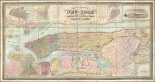
A Superlative Example of This Commanding Mid-Century Map of Manhattan.
Joseph Hutchins Colton's City & County Map of New-York Brooklyn, Williamsburgh, Jersey City & the adjacent Waters. . . Revised Edition, published in New York in 1859, offers a detailed representation of Manhattan during a crucial phase of its urban development. Displayed as a large dissected folding map, it encapsulates the city's transition with insets highlighting other significant cities and historically pertinent maps, ranging from an early view of Nieuw Amsterdam to the 1728 James Lyne survey of the city. Notably, this edition features a nascent rendition of Central Park, distinguishing itself from earlier iterations, which omitted the park entirely.
The mid-19th century marked a pivotal juncture in New York's history, as the city emerged as the burgeoning epicenter of commerce, culture, and innovation. The advent of Central Park, although sketched on the map in a rudimentary fashion, underscored a significant urban planning endeavor that would, in subsequent years, reshape the character of Manhattan. It's envisioned primarily through simple reservoir outlines, indicative of the park's early conceptual stage. Concurrently, the indicated prospective landfill into the Hudson River reflects the city's ambitions to expand and modify its geography in response to the growing demands of urbanization.
The inclusion of earlier cartographic works, such as Doctor Adrien Van der Dunk's 1656 view of Nieuw Amsterdam and James Lyne's 1728 survey, establishes a chronological tapestry, illustrating the city's metamorphosis over two centuries. These insets serve as both historical benchmarks and comparatives, allowing discerning viewers to appreciate the evolution and trajectory of New York's urban progression.
The auxiliary representations of Boston and Philadelphia, along with the detailed inset showcasing the principal roads, railroads, canals, and the proximity of villas from the city, paint a broader picture of the Northeastern United States' infrastructural and urban landscape during the mid-19th century. These additions enhance the map's contextual richness, situating Manhattan within a network of prominent cities and transit routes, emphasizing its integral role in the region's socio-economic fabric.
Lastly, the map stands as a testament to the cartographic precision and diligence of J.H. Colton & Co., adeptly capturing the nuances and intricacies of a city on the precipice of monumental change. The detailed renditions, from the streets of Brooklyn to the nascent outlines of Central Park, manifest the meticulous nature of the firm's work, crafting a visual narrative that continues to resonate with viewers more than a century later.
Rarity
OCLC locates only one other example of the 1859 edition, at NYPL. Based on library records, we can find editions of 1849, 1852, 1857 (seemingly the most common), 1859, 1862, and 1867. There might be an 1845 edition, as one entry indicates that early copyright date on the 1852 map.
G. W. & C. B. Colton was a prominent family firm of mapmakers who were leaders in the American map trade in the nineteenth century. Its founder, Joseph Hutchins Colton (1800-1893), was a Massachusetts native. Colton did not start in the map trade; rather, he worked in a general store from 1816 to 1829 and then as a night clerk at the United States Post Office in Hartford, Connecticut. By 1830, he was in New York City, where he set up his publishing business a year later.
The first printed item with his imprint is dated 1833, a reprint of S. Stiles & Company’s edition of David Burr’s map of the state of New York. He also printed John Disturnell’s map of New York City in 1833. Colton’s next cartographic venture was in 1835, when he acquired the rights to John Farmer’s seminal maps of Michigan and Wisconsin. Another early and important Colton work is his Topographical Map of the City and County of New York and the Adjacent Country (1836). In 1839, Colton began issuing the Western Tourist and Emigrant’s Guide, which was originally issued by J. Calvin Smith.
During this first decade, Colton did not have a resident map engraver; he relied upon copyrights purchased from other map makers, most often S. Stiles & Company, and later Stiles, Sherman & Smith. Smith was a charter member of the American Geographical and Statistical Society, as was John Disturnell. This connection would bear fruit for Colton during the early period in his career, helping him to acquire the rights to several important maps. By 1850, the Colton firm was one of the primary publishers of guidebooks and immigrant and railroad maps, known for the high-quality steel plate engravings with decorative borders and hand watercolors.
In 1846, Colton published Colton’s Map of the United States of America, British Possessions . . . his first venture into the wall map business. This work would be issued until 1884 and was the first of several successful wall maps issued by the firm, including collaborative works with D.G. Johnson. From the 1840s to 1855, the firm focused on the production of railroad maps. Later, it published a number of Civil War maps.
In 1855, Colton finally issued his first atlas, Colton’s Atlas of the World, issued in two volumes in 1855 and 1856. In 1857 the work was reduced to a single volume under the title of Colton’s General Atlas, which was published in largely the same format until 1888. It is in this work that George Woolworth (G. W.) Colton’s name appears for the first time.
Born in 1827 and lacking formal training as a mapmaker, G. W. joined his father’s business and would later help it to thrive. His brother Charles B. (C. B.) Colton would also join the firm. Beginning in 1859, the General Atlas gives credit to Johnson & Browning, a credit which disappears after 1860, when Johnson & Browning launched their own atlas venture, Johnson’s New Illustrated (Steel Plate) Family Atlas, which bears Colton’s name as the publisher in the 1860 and 1861 editions.
J.H. Colton also published a number of smaller atlases and school geographies, including his Atlas of America (1854-56), his Illustrated Cabinet Atlas (1859), Colton’s Condensed Cabinet Atlas of Descriptive Geography (1864) and Colton’s Quarto Atlas of the World (1865). From 1850 to the early 1890s, the firm also published several school atlases and pocket maps. The firm continued until the late 1890s, when it merged with a competitor and then ceased to trade under the name Colton.
![(American Revolution) [Manuscript Map of New York City and Northern New Jersey]](https://storage.googleapis.com/raremaps/img/small/69609.jpg)
![[Untitled hand-drawn plans for parcellation of New York City]](https://storage.googleapis.com/raremaps/img/small/83315.jpg)
![[ Manhattan Island / New York City ] To His Excellency Sr. Henry Moore Bart. Captain General and Governour in Chief in & over the Province of New York and the Territories . . . This Plan of the City of New York and its Environs, Surveyed and Laid Down: Is most Humbly Dedicated . . . B. Ratzer](https://storage.googleapis.com/raremaps/img/small/105080.jpg)
