|
||

|

|
|

|
Swabia, issued by Lizars around 1840, offers a detailed geographical perspective of the region, stretching from Lake Constance to the Duchy of Wurtemberg. Through its delineation of towns, roads, rivers, mountains, and lakes, the map provides an in-depth look into Swabia's landscape during the mid-19th century.
The 19th century was a period of transformation for Swabia. Following the dissolution of the Holy Roman Empire due to the Napoleonic Wars, territories were reorganized. By 1806, significant portions of Swabia were integrated into the Kingdom of Württemberg and the Kingdom of Bavaria. This period also marked the rise of nationalism and early industrialization, as Swabia's towns and infrastructure became pivotal in these socio-economic shifts.
Key towns in Swabia, as highlighted on the map, include Augsburg, Ulm, and Tübingen. Augsburg, an ancient Roman city, became a center for the textile industry during this era, and its banking institutions were of significant note. Ulm, situated on the banks of the Danube River, developed as a crucial transportation and trade hub. Tübingen, meanwhile, maintained its reputation as a center of learning, with its university attracting scholars and students from across Germany.
Lake Constance's inclusion reflects its trade significance and the strategic role it played for Swabia in terms of regional connectivity. The Duchy of Wurtemberg, prominent on the map, was an epicenter of political and administrative activities, representing Swabia's shifting political landscape.
The Lizars were a Scottish family of engravers and printers who produced many views and maps. Daniel Lizars Sr. (1754-1812) was the son of a shoemaker, but he apprenticed with Andrew Bell, a printer and engraver. Lizars set up his own printworks near St. Giles Cathedral and took on his own apprentices, including George Bartholomew, whose son John would go on to found the important mapmaking firm later know as John Bartholomew & Son Ltd.
Daniel Sr. had three sons: Daniel Jr., John, and William Home. He also had a daughter, Jane Home. Daniel Jr. (1793-1875), the youngest of the boys, apprenticed in his father’s shop alongside George Bartholomew. When his father died in 1812, Daniel Jr. took over much of the business, expanding it and specializing in maps. The company went bankrupt in 1832, however, and Daniel emigrated to Canada.
John Lizars (1792-1860), the middle son, studied medicine and became Professor of Surgery at the Royal College of Surgeons of Edinburgh, as well as senior surgeon at the Royal Infirmary of Edinburgh.
William Home Lizars (1788-1859), the eldest, also apprenticed in his father’s shop. After learning engraving, William entered the Trustees’ Academy to learn under John Graham. He was a skilled painter and artist. When his father died, and after his Daniel Jr. left, he carried on printing and invented a method of etching that looks like wood engraving.
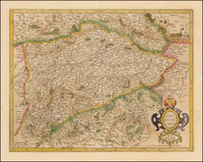
![[Bavaria and Baden-Württemberg] A Benigni Lettori, ecoui la descrittione del Ducato di Baviera, con gl altri Dominiijcirconvicini di nuovo con ogni deligentia revisto et dato in luce l'anno MDLXX . . . 1602 . . .](https://storage.googleapis.com/raremaps/img/small/75011.jpg)

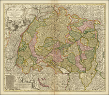
![[Upper Rhine River] Vera totius Marchionatus Badensis et Hochbergensis ceterorumque Ducatuum Landravionatuum . . . .](https://storage.googleapis.com/raremaps/img/small/86776.jpg)