


|
||

|

|
|

|
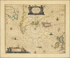
The Only 16th Century Map of the Mythical Island of Frisland
First state of the only 16th Century map of the mythical island of Frisland in the North Atlantic.
In the annals of cartographic history, few tales are as intriguing as those of phantom islands that, for centuries, dotted the world maps only to vanish in the light of better exploration. Frisland, a fictitious island in the North Atlantic, is one such mythical place that occupied the imaginative landscapes of medieval mapmakers and navigators. Its existence, albeit fictitious, and its eventual erasure from maps offer profound insights into the evolving nature of cartography and the interplay between myth, commerce, and exploration.
The story of Frisland is deeply embedded in the chronicles of European exploration during the Middle Ages. Frisland was commonly believed to be situated somewhere between Iceland and Greenland. Frisland began to make regular appearances on maps during the 16th and 17th centuries. The famed Zeno map of 1558, which was said to depict a 14th-century voyage by the Zeno brothers of Venice, prominently featured Frisland.
What is truly remarkable about the present map Frisland is its detail, here show with mountains, bays, settlements and even what appears to be organized farming land, suggesting that mapmakers had elaborate descriptions of the island. Yet no explorer ever set foot there. Its portrayal was purely speculative, drawing from narratives, popular myths, and highly questioned accounts, such as the story of Nicolo Zeno's voyage, which reportedly reached Frisland in about 1380.
Rarity
The map is extremely rare on the market.
There are at least 2 states of the map, with a later state bearing the imprint of Pietro de Nobilis formis.
The Zeno Map and the mythical island of Frisland
The Zeno family was part of the Venetian elite; indeed, their family had controlled the monopoly over transport between Venice and the Holy Land during the Crusades. Nicolo Zeno set off in 1380 to England and Flanders; other evidence seems to corroborate this part of the voyage. Then, his ship was caught in a huge storm, blowing him off course and depositing him in the far North Atlantic. He and his crew were wrecked on a foreign shore, the island of Frislanda (sometimes Friesland or Freeland).
Thankfully, the shipwrecked Venetians were found by King of Frisland, Zichmni, who also ruled Porlanda, an island just south of Frisland. Zichmni was on a crusade to conquer his neighbors and Nicolo was happy to help him strategize. Nicolo wrote to his brother, Antonio, encouraging him to join him and, good navigator that he was, Antonio sailed for Frisland and arrived to help his brothers. Together, they led military campaigns against Zichmni’s enemies for fourteen years.
Their fights led the brothers to the surrounding islands, presumably enabling them to make their famous map. Zichmni attempted to take Islanda but was rebuffed. Instead, he took the small islands to the east, which are labeled on this map. Zichmni built a fort on one of the islands, Bres, and he gave command of this stronghold to Nicolo. The latter did not stay long, instead sailing to Greenland, where he came upon St. Thomas, a monastery in Greenland with central heating. Nicolo then returned to Frisland, where he died four years later, never to return to Venice.
Antonio, however, was still alive. He ran into a group of fishermen while on Frisland. These fishermen had been on a 25-year sojourn to Estotiland. Supposedly, Estotiland was a great civilization and Latin-speaking, while nearby Drogeo, to the south, was full of cannibals and beasts. Antonio, on Zichmni’s orders, sought these new lands, only to discover Icaria instead. The Icarians were not amenable to invasion, however, and Antonio led his men north to Engroneland, to the north. Zichmni was enthralled with this new place and explored inland. Antonio, however, returned to Frisland, abandoning the King. From there, Antonio sailed for his native Venice, where he died around 1403.
News of the discoveries and the first version of the Zeno map was published in 1558 by another Nicolo Zeno, a descendent of the navigator brothers. Nicolo the Younger published letters he had found in his family holdings, one from Nicolo to Antonio and another from Antonio to their other brother, Carlo, who served with distinction in the Venetian Navy. They were published under the title Dello Scoprimento dell’isole Frislanda, Eslanda, Engrouelanda, Estotilanda, & Icaria, fatto sotto il Polo Artico, da due Fratelli Zeni (On the Discovery of the Island of Frisland, Eslanda, Engroenland, Estotiland & Icaria, made by two Zen Brothers under the Arctic Pole) (Venice: Francesco Marcolini, 1558).
At the time of publication, the account attracted little to no suspicion; it was no more and no less fantastic than most other voyage and travel accounts of the time. Girolamo Ruscelli published a version of the Zeno map in 1561, only three years after it appeared in Zeno’s original work. Ruscelli was a Venetian publisher who also released an Italian translation of Ptolemy. Ruscelli had moved to Venice in 1549, where he became a prominent editor of travel writings and geography.
Ruscelli was not the only geographer to integrate the Zeno map into his work. Mercator used the map as a source for his 1569 world map and his later map of the North Pole. Ortelius used the Zeno islands in his map of the North Atlantic. Ramusio included them in his Delle Navigationo (1583), as did Hakluyt in his Divers Voyages (1582) and Principal Navigations (1600), and Purchas (with some reservation) in his Pilgrimes (1625). Frisland appeared on regional maps of the North Atlantic until the eighteenth century.
In the nineteenth century, when geography was popular as both a hobby and a scholarly discipline, the Zeno account and map came under scrutiny. Most famously, Frederick W. Lucas questioned the validity of the voyage in The Annals of the Voyages of the Brothers Nicolo and Antonio Zeno in the North Atlantic (1898). Lucas accused Nicolo the Younger of making the map up, using islands found on other maps and simply scattering them across the North Atlantic. He also accused Nicolo of trying to fabricate a Venetian claim to the New World that superseded the Genoan Columbus’ voyage. Other research has revealed that, when he was supposed to be fighting for Zichmni, Nicolo was in the service of Venice in Greece in the 1390s. He is known to have drafted a will in 1400 and died—in Venice, not Frisland—in 1402.
Scholars still enjoy trying to assign the Zeno islands to real geographic features. For example, Frisland is thought to be part of Iceland, while Esland is supposed to be the Shetlands. Some still believe the Zenos to have sailed to these lands. Most, however, view the voyage and the map as a reminder of the folly and fancy (and fun) of early travel literature and cartography. Whatever the truth, the Zeno map and its islands are one of the most enduring mysteries in the history of cartography.
![[Signed Political Satire Artwork] Vietnam ... Vietnam ... Vietnam ...](https://storage.googleapis.com/raremaps/img/small/68726.jpg)
![(Mapseller Correspondence) [Rufus Blanchard Letter written to Charles Marseilles] (May 23, 1888)](https://storage.googleapis.com/raremaps/img/small/86063.jpg)
![Повстанцы 1863 Года [(Polish) Insurgents of 1863]](https://storage.googleapis.com/raremaps/img/small/52719.jpg)