


|
||

|

|
|

|
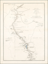
Nanjing in the 17th Century
Interesting view of the approach to Nanjing, from Mallet's Description de l'Univers.
Nanjing (often referred to in earlier times as Nanking) is located on the southern banks of the Yangtze River. It has historically been a significant political, economic, and cultural center in China.
At the beginning of the 17th century, the Ming Dynasty was experiencing decline. Economic strains, internal strife, and external pressures were weighing heavily on the empire. Nanjing, as one of the important cities of the Ming, reflected this decline but still retained its prominence as a political and cultural hub.
However, by the mid-17th century, the tides of power began to shift. The city became the epicenter of resistance against the Manchu invaders from the north. In 1644, as Beijing fell to the Manchus, the Ming loyalist Zhu Yousong was enthroned as the Hongguang Emperor in Nanjing, making it the capital of the Southern Ming Dynasty. However, this would be short-lived. By 1645, the Qing forces captured Nanjing, marking a significant blow to the dwindling Ming resistance.
Yet, even amidst the political upheavals, Nanjing continued to flourish as a cultural and economic center. Its position along the Yangtze River made it a crucial point in river trade. Merchants from different parts of China and even from overseas frequented Najking, leading to a bustling trade scene.
The city also remained a center for education and the arts. Traditional Chinese scholarly pursuits, including poetry, calligraphy, and painting, continued to thrive. Scholars and intellectuals, many of whom were wary of the new Qing regime, congregated in Nanking, keeping the flame of Ming culture alive. Some were involved in compiling histories of the fallen Ming Dynasty, while others focused on arts, producing masterpieces that are celebrated even today.
Alain Mannesson Mallet (1630-1706) was a French mapmaker and engineer who served in the armies of Louis XIV. After rising through the ranks, Mallet was appointed as Inspector of Fortifications, a job which also required mathematical skills and which made him a competent military engineer. Eventually, he joined the court of Louis XIV at Versailles, where he taught math and focused on writing.
Mallet is best known for his Description de L’Univers, first published in 1683, in five volumes. A wide-ranging geographical work, the Description included textual descriptions of the countries of the world, as well as maps of the celestial sky and the ancient and modern worlds. The Description continued to be published until the early eighteenth century. He also published a work in three volumes on warfare (1684) and a primer on geometry (1702).
![[ Mongolia & China ] Tartaricus](https://storage.googleapis.com/raremaps/img/small/97226.jpg)
![[ China ] Carte vom Reich China nach der neuesten grossen Carte des Herrn. d'Anville und Hase entworfen 1762](https://storage.googleapis.com/raremaps/img/small/103353.jpg)