|
||

|

|
|

|
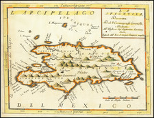
I. d'Hispaniola et P.to Rico by Alain Manesson Mallet, and published from Paris in 1683, presents an interesting historical depiction of Hispaniola and Puerto Rico, complemented by a collection of neighboring islands and three illustrative naval battles set in the North Atlantic waters. Significantly located between Hispaniola and Puerto Rico, Saona and Mona islands are central visual anchors, while to Hispaniola's north, the Inagua islands and Mayaguana are depicted, and to the south, the viewer finds Île-à-Vache.
The 17th century, particularly its latter half, was a time of intense maritime exploration, territorial disputes, and the establishment of trans-Atlantic trade routes. The Caribbean, including the islands of Hispaniola and Puerto Rico, stood at the crossroads of these geopolitical endeavors. Naval skirmishes and battles were frequent, a consequence of European colonial powers vying for dominance over strategic territories and waterways. These were no mere remote outposts; they were critical nexuses in global trade, power, and navigation. Mallet's inclusion of three naval battles underscores the significance and volatility of the region during this period.
Alain Manesson Mallet's cartographic mastery shines in this piece. Known for his comprehensive work Description de l' Univers, this map exemplifies the breadth and depth of his ambition in documenting the known world of the 17th century. His precision in detailing the islands, both major and minor, combined with the dynamic representation of naval engagements, provides viewers with both geographical insights and a historical tableau of the era.
Moreover, the presence of islands such as Île-à-Vache, Saona, and Mona, while perhaps lesser-known in popular narratives, gives a sense of the complexity and richness of Caribbean geography. These islands, though smaller in landmass, played vital roles in maritime navigation, as stopovers, refuges, and sometimes contested territories. In situating them alongside the major islands of Hispaniola and Puerto Rico, Mallet's map speaks to a holistic understanding of the Caribbean space and its multifaceted geopolitical significance.
Alain Mannesson Mallet (1630-1706) was a French mapmaker and engineer who served in the armies of Louis XIV. After rising through the ranks, Mallet was appointed as Inspector of Fortifications, a job which also required mathematical skills and which made him a competent military engineer. Eventually, he joined the court of Louis XIV at Versailles, where he taught math and focused on writing.
Mallet is best known for his Description de L’Univers, first published in 1683, in five volumes. A wide-ranging geographical work, the Description included textual descriptions of the countries of the world, as well as maps of the celestial sky and the ancient and modern worlds. The Description continued to be published until the early eighteenth century. He also published a work in three volumes on warfare (1684) and a primer on geometry (1702).

![[Turks & Caicos, Bahamas, Hispaniola and Cuba]. Carte Reduite Des Debouquements, De St. Domingue, Levee, Dressee et Publiee par Ordre du Roi . . . 1787](https://storage.googleapis.com/raremaps/img/small/83475.jpg)