|
||

|

|
|

|
San Diego's Embarcadero in the 1880s
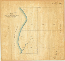
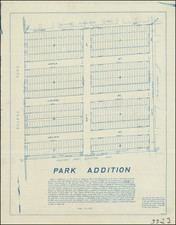
A wonderful hand-drawn map showing the area south of Market Street between present-day Kettner Blvd. and Columbia Streets, part of lot no. 793 within Alonzo Horton's New Town subdivision. Market Street is here labeled H Street, India Street is indicated, but Kettner Blvd., being named after a 20th-century Congressman, obviously doesn't appear here. The route of the Santa Fe Railroad, which is indicated on the map, helps pinpoint the area as the current site of the Manchester Grand Hyatt Hotel and part of Seaport Village at the Embarcadero. The bit of blue wash color above a dike suggests that the area shown has been much extended through infill development.
1880s Real Estate Boom
At the time of this map San Diego was experiencing a speculative boom. According to Glenn S. Dumke:
The San Diego boom was characterized by much speculation and by several flamboyant, highly publicized enterprises. Business lots in the city proper rose from $25 to $2500 per front foot, small stores rented for $300 to $500 per month... Statistically, San Diego's progress during the boom's height appears spectacular. In 1868 county realty assessments were only $600,000; in 1886 they reached $13,838,030; in 1887, $19,542,864. Total assessments (city and county) shot up to more than $40,000,000 in 1888, but dropped back to $26,800,000 in 1890. - The Boom of the Eighties in Southern California, pages 140-141.
Many of the speculators pinned their hopes on the promise of new railroad lines linking the town with economic centers north and east. Alonzo Horton's New Town finally took off, with San Diego businesses spreading north to H Street (present-day Market Street), which was considered the main crossroad. Eventually, San Diego expanded to D Street (present-day Broadway) and beyond as merchants moved northward. In 1885, the California Southern Railroad, a subsidiary of the Atchison, Topeka, and Santa Fe line, established tracks into San Diego. This line helped grow San Diego: in 1886 the city's population exploded from 7,500 to 12,000, and likely reached 35,000 by 1888.
Names on the Map
One of the plats along the east side of India Street is simply labeled "Italian." This is intriguing as the remaining lots are identified by names of the owners or indicated as vacant. The names comprise a mix of locally prominent but now mostly obscure individuals, surely some of the earliest true believers in San Diego's future: George Whaley (likely George Hay Ringgold Whaley, a son of Thomas Whaley, a prominent San Diego pioneer who built the first brick house in town), Wm. Whaley, Eric Lindstedt, Pete Martinsen, Andrew Wilson, Peter Francis, Patrick Kirk, Pat Sweeny, Jno. Boyle, Walter Carter, Steve Malloney, Nick Burk, August Peterson, Harry Newman, George Dickson, Dan McCauley, Dennis Lynch, Geo. Townsend, Jim Connors, Jack Fitzpatrick, Montana Jack, Neal Donahue, John Donahue, Chas. Pipkins, Herman Beechner.
The map is labeled "Map - Exhibit No. 5," which suggests it was made for a legal case involving the land shown.
Rarity
The present map is a unique or nearly unique survival. Such 19th-century manuscript surveys for Southern California are rarely appear in the market and when found at all are usually held in institutional collections.
![[ Oceanside / Camp Pendleton ] Map of Swamp Land Survey No. 1 Location No. 908 Situated in San Diego County, Cal. . . . Surveyed under instructions of Hon. M.J. Wright, Surveyor General of California, by S.L. Ward, County Surveyor of San Diego County on the 8th, 9th 10th & 11th of October, 1900.](https://storage.googleapis.com/raremaps/img/small/96547.jpg)