|
||

|

|
|

|
Geopolitical Canvas of a Transforming Continent
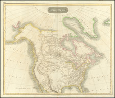
Anthony Finley's 1826 map of North America is not just a representation of geographical spaces and natural boundaries; it's an evocative reflection of the geopolitical sentiments, explorations, and myths of the era.
One of the most striking features of the map is the delineation of Russian Possessions, modern-day Alaska, with the powerful assertion of the “54 40 or fight” border, confronting the Russian claims. This wasn't just a cartographic detail but a potent political statement, laying bare the expansionist ambitions of the United States and foreshadowing the tension and territorial disputes that would dominate the continent for the decades to follow.
In the Pacific Northwest, the vast expanse labeled as the Missouri Territory speaks to a transitional period in the exploration and settlement of the American West. The knowledge synthesized from the Lewis & Clark expedition and the Hunt & Stuart journey to Astoria is evident, showcasing the increasing understanding of the continent's interior. Notably absent is the Oregon Trail – a future artery of westward migration that would come to symbolize American manifest destiny.
The US/Russia Border, as settled by the Convention of April 1824, further solidifies the evolving territorial claims. The acknowledgment of this border underscores the power plays of the time and signifies the balance of power and mutual recognition of territories between two significant global players.
Texas, depicted as part of the Intendency of San Luis Potosi, presents a snapshot of a region on the cusp of significant change. Locations like Galveston, San Antonio, and Loredo are prominently displayed, hinting at their importance in the years to come. The annotations of Indigenous communities such as the Wako Indians and the Comanches are significant, showcasing the vibrant, multifaceted tapestry of cultures and communities that called the region home.
Further west, the portrayal of several mythical rivers in Upper California flowing from the Great Basin to the Pacific captures the combination of known truths and speculative beliefs of the era. These rivers, products of a mix of indigenous narratives and explorers' hopes, showcase the still-evolving understanding of the region.
The depiction of the double-wide Arkansas Territory and a vast Northwest Territory further emphasizes the nascent state of understanding and the ongoing process of territorial definition. Meanwhile, the multitude of Native American tribes sprinkled across the West is both an acknowledgment of their presence and a sobering prelude to the upheavals and displacements they would soon face.
The History of Russian America
Russian America refers to the period from 1733 to 1867 when Russia established settlements and trading posts on the Pacific coast of North America, primarily in the area of present-day Alaska. It was the hub of the Russian fur trade in North America.
The initial Russian interest in North America stemmed from the quest for valuable furs, particularly sea otter pelts. Vitus Bering, a Danish explorer working for the Russian Empire, led the first expedition to the region in the 1740s, culminating in the discovery of the Alaskan mainland. Following Bering's exploration, the Russian fur trade rapidly expanded into the Aleutian Islands and later onto the mainland.
The Russian American Company, founded in 1799, was granted a monopoly over trade in the region and played a dominant role in the administration and colonization of Russian America. With its establishment, Orthodox Christian missions, primarily aimed at the indigenous population, became more prevalent.
However, Russia's presence in North America was always tenuous. Logistical challenges, competition with British and American fur traders, and conflict with indigenous groups made operations in Russian America difficult. With declining profits from the fur trade and recognizing the strategic vulnerability of their North American territories, Russia sought a buyer.
In 1867, U.S. Secretary of State William H. Seward successfully negotiated the purchase of Alaska from Russia for $7.2 million, marking the end of Russian America. The decision was initially controversial in the U.S., with the territory mockingly referred to as "Seward's Folly," but the discovery of gold and rich natural resources in subsequent years validated the acquisition.
54 40 or Fight: Boundary Dispute and Campaign Slogan
"54 40 or Fight" was a slogan originating in the mid-19th century, encapsulating the United States' expansionist fervor and the boundary dispute with Britain in the Oregon Country.
The Oregon Country, an expansive region on the Pacific Coast, was jointly occupied by the U.S. and Britain following the Treaty of 1818. The treaty had allowed for joint occupancy for ten years but did not specify the boundary. As the end of this period approached, settlers and politicians began to push for a resolution to the border issue.
The slogan "54 40 or Fight" referred to the latitude 54 degrees 40 minutes, the northernmost boundary of the Oregon Country. American expansionists believed that the U.S. had a manifest destiny to claim the entire region up to that latitude, which would include present-day British Columbia. The slogan thus encapsulated a bold assertion of American territorial claims and a willingness to go to war with Britain if these claims were not recognized.
The slogan gained significant traction during the 1844 U.S. presidential election. Democratic candidate James K. Polk adopted it as a central part of his campaign, signaling his strong stance on the Oregon boundary issue. Polk's subsequent victory was seen as a mandate from the American people to assert U.S. claims over the entire Oregon Country.
However, pragmatism ultimately prevailed. Neither side wanted war, and a compromise was reached in 1846 with the Oregon Treaty, which established the boundary at the 49th parallel. While the "54 40 or Fight" demand was not realized, the U.S. did secure its claims to the valuable ports and territories of the Pacific Northwest.
Anthony Finley (1784-1836) was an American map publisher. Little is known about his life. He is presumed to have been born in Philadelphia, where he also died. A publisher, Finley was also involved in several Philadelphia civic and professional societies such as the Philadelphia Apprentices’ Library. He may have been in business as early as 1809 and his first publication dates from ca. 1811.
His first maps also date from this year, with two maps in Daniel Edward Clarke’s Travels in Various Countries of Europe, Asia, and Africa. The first atlas published by Finley appeared in 1818, the Atlas classica, or, Select maps of ancient geography, both sacred and profane, for the use of colleges and schools in the United States. He is best known for his A New General Atlas Comprising a Complete Set of Maps (1824), which was a bestseller. There were two editions in 1824, with annual editions until 1834.
Finley was part of the first generation of American publishers who produced high quality, precise maps on American soil. He was in competition with other Philadelphia publishers, for example Henry S. Tanner. Finley’s A New American Atlas Designed Principally to Illustrate the Geography of the United States of America (1826) closely mirrors Tanner’s A New American Atlas Containing Maps of the Several States of the North American Union, with similar groupings of maps; the main difference is the smaller scale of Finley’s maps. Finley printed two editions of this atlas.

![[ Trans-Atlantic Cable ] Amerique Septentrionale avec l'indication des Principaux Courants marins d'Amerique en Europe](https://storage.googleapis.com/raremaps/img/small/98084.jpg)