|
||

|

|
|

|
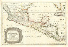
Mexique ou Nouvelle Espagne by Alain Manesson Mallet, published in Paris in 1683, is an exquisitely detailed miniature map encompassing the Southwest, Baja California, Mexico, and Central America, further extending to Louisiana, the Mississippi, and all of Florida. Elegantly engraved and adorned, it presents an intricate representation of the territories during a period of exploration, colonization, and transformation.
In the latter half of the 17th century, the regions depicted in this map were of immense interest to European powers, especially Spain, which controlled vast territories in the Americas. The map's title, translated as "Mexico or New Spain," reflects the terminology of the time, when the Spanish Crown referred to its territories in the Americas as New Spain. The territories spanned present-day Mexico, the Southwestern United States, and parts of Central America.
Mallet's map illustrates not only the geography but also the ambitions and rivalries that defined the period. The extension of the map to encompass Louisiana and Florida is particularly noteworthy, as these areas were the subject of contestation among European powers. Spain, France, and England all sought to exert control over these lands, resulting in a complex pattern of alliances, treaties, and conflicts.
The artistic embellishments in Mallet's work lend a richness and depth to the cartographic representation. Though miniature in size, the map's engravings are rendered with exceptional skill, capturing the topographical features of the land and lending an aesthetic charm to the geographical information. The map may also reflect prevailing European perceptions and misconceptions of the New World, which was still being explored and mapped.
From a historical perspective, the Mexique ou Nouvelle Espagne provides valuable insights into the geopolitical landscape of the late 17th century. It captures a moment in time when European powers were actively exploring and colonizing the Americas, shaping the boundaries and identities of the territories that would later become modern nation-states.
Alain Manesson Mallet's map stands as both a work of art and a historical document, reflecting the interplay between exploration, politics, and cartography in the Age of Discovery. Its detailed portrayal of a diverse and contested region, skillfully rendered and aesthetically appealing, offers a window into a fascinating period of human history, where the pursuit of knowledge, power, and beauty converged.
Alain Mannesson Mallet (1630-1706) was a French mapmaker and engineer who served in the armies of Louis XIV. After rising through the ranks, Mallet was appointed as Inspector of Fortifications, a job which also required mathematical skills and which made him a competent military engineer. Eventually, he joined the court of Louis XIV at Versailles, where he taught math and focused on writing.
Mallet is best known for his Description de L’Univers, first published in 1683, in five volumes. A wide-ranging geographical work, the Description included textual descriptions of the countries of the world, as well as maps of the celestial sky and the ancient and modern worlds. The Description continued to be published until the early eighteenth century. He also published a work in three volumes on warfare (1684) and a primer on geometry (1702).
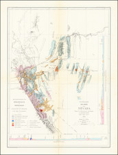
![[ Republic of Texas ] Central America II. Including Texas, California and the Northern States of Mexico](https://storage.googleapis.com/raremaps/img/small/93534.jpg)