


|
||

|

|
|

|
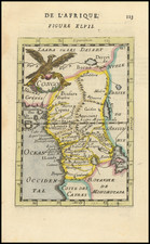
Mapping The Congo Region
Finely executed map of the Congo Basin and adjoining regions, including The Free State of Congo, based in part of the explorations of Henry Morgan Stanley.
The backdrop to this map is the fervent 'Scramble for Africa' in the late 19th century. During this period, European powers were voraciously dividing the African continent, staking their claims and marking their territories. The Congo, rich in resources and strategically located, quickly became a focal point for many of these nations. This map encapsulates the era, illustrating not just the geographical intricacies but also the simmering geopolitical ambitions.
The map includes a credit for Henry M. Stanley, who had been an important firsthand explorer of the region. However, the map also carries an advisory regarding its accuracy. Stanley's most renowned achievement was his discovery of David Livingstone, a missionary lost in central Africa. In 1871, Stanley found him in Ujiji near Lake Tanganyika with the famous words, "Dr. Livingstone, I presume?" Following his encounter with Livingstone, Stanley undertook multiple significant expeditions. Among these was his 3,000-mile journey through the Congo River, which played a pivotal role in King Leopold II's establishment of the Congo Free State.
The map notes that as of its creation in 1877, parts of the Congo River, stretching from Stanley Falls to Yellala, were marked based on compass directions and altitude observations. Yet, a day's error in the long journey meant deviations in some regions by up to 30 kilometers. This discrepancy underlines the challenges of map-making during that era, heavily reliant on human observations and susceptible to errors. The Congo River's portrayal is updated based on around 400 latitude and longitude observations starting from Boma.
Furthermore, various sections of the map, particularly the Kwilu-Niadi valley and the space between Kwilu and Congo, incorporate details from Spencer Burns, Lieutenant Van de Velde, Lieutenant Destrain, and Mr. Mikic, all representing the International Association of the Congo. Their collective contributions echo the broader European collaboration and vested interest in this region.
The map also utilizes a color-coded system to demarcate territories. The Free State of Congo is shaded in pink. A red line highlights the free trade area, while the French and Portuguese territories are distinctly colored in brown and green, respectively.
The regional geopolitics of the second half of the 19th century was characterized by aggressive European colonization, as powers like Britain, France, Belgium, and Portugal sought to expand their empires in Africa. The Berlin Conference of 1884-1885, which formalized the Scramble for Africa, allowed European nations to stake their claims in Africa, often without any consideration for the indigenous populations.
Rarity
We note a single example in the Museo Galileo.
![[Republic of Liberia]](https://storage.googleapis.com/raremaps/img/small/76840.jpg)