|
||

|

|
|

|
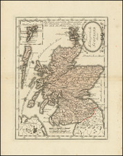
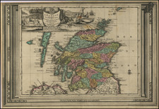
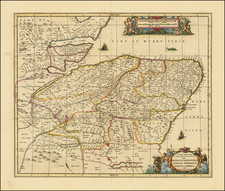
Nova et accurata totius Regni Scotia, issued by Matthias Seutter in Augsburg in 1740, offers a detailed representation of Scotland, delineating its provinces and nearby isles. It methodically categorizes prominent cities, towns, villages, castles, as well as archiepiscopal and episcopal seats, highlighting the academic centers of the period.
The 18th century was a significant era for cartographic advancements in Europe. For Scotland, this time marked its adjustment post the 1707 Acts of Union and the onset of the Scottish Enlightenment, a period where the nation saw strides in cultural, literary, and scientific fields. This map provides insight into Scotland's geographical layout and its cultural evolution during this transformative period.
The map's additional elements, such as the allegorical cartouches and a coat of arms, not only enhance its visual appeal but also mirror the prevailing cultural sentiments. These decorative features are indicative of the period's cartographic style and serve as markers of Scotland's regional identity within the broader British Isles.
Rarity
We have only had this map twice before in over 20 years.
Matthäus Seutter (1678-1757) was a prominent German mapmaker in the mid-eighteenth century. Initially apprenticed to a brewer, he trained as an engraver under Johann Baptist Homann in Nuremburg before setting up shop in his native Augsburg. In 1727 he was granted the title Imperial Geographer. His most famous work is Atlas Novus Sive Tabulae Geographicae, published in two volumes ca. 1730, although the majority of his maps are based on earlier work by other cartographers like the Homanns, Delisles, and de Fer.
Alternative spellings: Matthias Seutter, Mathaus Seutter, Matthaeus Seutter, Mattheus Seutter
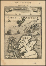
![[Southern Scotland] Des Konigreichs Scotland sudlicher Theil Nro. 87](https://storage.googleapis.com/raremaps/img/small/83654.jpg)