|
||

|

|
|

|
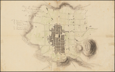
This map of Mexico City drawn in the style of Braun & Hogenberg birdseye views. It depicts the city in the middle of a large lake, drawn from an elevated perspective.
The city's layout is orderly, showing square blocks of buildings. TA network of canals runs through the city, with causeways linking it to the mainland.
Mexico City has a rich history that spans many centuries. The origins of the city can be traced back to the Aztecs who, according to legend, established their capital, Tenochtitlan, on an island in Lake Texcoco in 1325. The city became the center of the Aztec Empire, renowned for its complex social, political, and religious structures.
In 1519, the Spanish conquistador Hernán Cortés arrived in Mexico and by 1521, after a brutal campaign, the Aztec Empire had fallen to the Spaniards. Cortés chose the site of the Aztec capital for the new Spanish capital of the region, calling it Mexico City.
The Spanish initiated a comprehensive urban development plan, constructing European-style buildings and infrastructure on the ruins of Tenochtitlan. A grand cathedral, El Zócalo, was built on the site of the Aztec Templo Mayor, symbolizing the imposition of Catholicism on the indigenous people. By the mid-16th century, Mexico City was largely remodeled in the Spanish style, although many indigenous people continued to live there and maintain some of their traditions.
In the latter half of the 16th century, Mexico City continued to grow and prosper. Despite occasional setbacks, such as epidemics and floods, it became an important economic and political hub of the Spanish colonial territories. By 1650, Mexico City was one of the most populous cities in the world and the administrative, economic, and cultural heart of New Spain
Theodor de Bry (1528-1598) was a prominent Flemish engraver and publisher best known for his engravings of the New World. Born in Liege, de Bry hailed from the portion of Flanders then controlled by Spain. The de Brys were a family of jewelers and engravers, and young Theodor was trained in those artisanal trades.
As a Lutheran, however, his life and livelihood were threatened when the Spanish Inquisition cracked down on non-Catholics. De Bry was banished and his goods seized in 1570. He fled to Strasbourg, where he studied under the Huguenot engraver Etienne Delaune. He also traveled to Antwerp, London, and Frankfurt, where he settled with his family.
In 1590, de Bry began to publish his Les Grands Voyages, which would eventually stretch to thirty volumes released by de Bry and his two sons. The volumes contained not only important engraved images of the New World, the first many had seen of the geographic novelties, but also several important maps. He also published a collection focused on India Orientalis. Les Grands Voyages was published in German, Latin, French, and English, extending de Bry’s fame and his view of the New World.
Mathaus Merian (1593-1650) was the father of engraver Matthäus the Younger, and of the painter, engraver, and naturalist Maria Sibylla Merian. He was born in Basel, Switzerland and trained in engraving in Zurich. After a time in Nancy, Paris and Strasbourg, he settled in Frankfurt. While there, he worked for Johann Theodor de Bry, the publisher and son of the travel writer. In 1617, he married Maria Magdalena de Bry, Johann Theodor’s daughter. In 1623, Merian took over the de Bry publishing house upon the death of his father-in-law. Merian’s best known works are detailed town views which, due to their accuracy and artistry, form a valuable record of European urban life in the first half of the sixteenth century
![{Central Mexico] Mapa de producciones](https://storage.googleapis.com/raremaps/img/small/62148.jpg)