|
||

|

|
|

|
St. Mary's River, Cornfield Harbor and Pt. Lookout, Maryland, drafted under the aegis of A.D. Bache as Superintendent of the Survey of the Coast of the United States in 1859, offers a meticulous trigonometrical depiction of the north coast at the entrance to the Potomac River in Maryland. The detailed charting includes features ranging from the depths of the waters as signified by soundings to navigational directions, assisting sailors traversing the region from both the eastward and westward approaches.
The mid-19th century bore witness to a period of flourishing maritime activity in the United States, both in terms of trade and exploration. Maryland, nestled along the Atlantic coast, was no exception to this trend. The St. Mary's River and its surrounding harbors played pivotal roles in the maritime ecosystem of the period, providing safe anchorages and navigational points for vessels. This map, with its specific references to the Piney Point and Point Lookout lighthouses, underscores the significance of lighthouses as navigational aids during an era when maritime safety was heavily reliant on the visible presence of such structures.
The triangulation work, executed by John Farley and his team between 1857 and 1858, stands as testimony to the scientific rigor that underpinned the creation of this cartographic document. The topography and hydrography sections, dated between 1849 and 1859, attest to the depth of research and observation that went into this survey. The precise delineation of the bottom's figure, based on selected characteristic soundings, manifests the focus on combining navigational utility with topographical accuracy.
Furthermore, the detailed sailing directions provided for approaches from both the eastward and westward emphasize the map's utility for mariners. The mentions of specific bearings, distances, and landmarks, such as the Wind Mill on Priest's Point and the anchorage specifications at St. Inigo's Creek, accentuate the map's function as a vital navigational tool for the seafaring community during the mid-19th century.
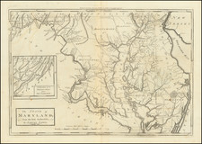
![[Jefferson's Notes on the State of Virginia] Observations sur la Virginie [with the map:] A Map of the country between Albemarle Sound, and Lake Erie, comprehending the whole of Virginia, Maryland, Delaware, and Pensylvania, with parts of several other of the United States of America. Engraved for the Notes on Virginia.](https://storage.googleapis.com/raremaps/img/small/51828.jpg)
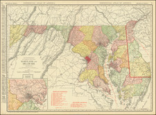
![Map of the Main Portion of Pittsburg and Allegheny [with verso] Delaware. Maryland.](https://storage.googleapis.com/raremaps/img/small/84993.jpg)