


|
||

|

|
|

|
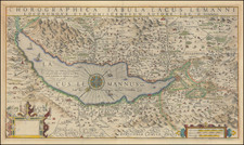
Rare first state of this important map of the Lake Geneva, first published by Jodocus Hondius in 1606. This rare first state includes five portraits of Calvin, Farellus, Viretus, Beza and Goulartius, which would be removed in later states of the map, honoring 5 major figures of the Protestant Reformation.
Oriented with southeast at the top, the map offers a detailed view of the Lake Geneva region. It encompasses the area from the Rhone River to Geneva, representing the entire Canton of Geneva. The map is its detailed depiction of various landmarks, with emphasis on the mountainous areas around the Lake and its important river valleys.
In addition to towns and fortresses, the map also denotes towers, wineries, and castles. Among these landmarks, "Chateau Chillon" stands out, a location that later gained recognition through the works of writers like Rousseau and Byron.
Visually, the map integrates functional elements such as the depiction of sailing ships in Lake Geneva and a large compass rose positioned in the center of the lake. Interestingly, there's an unfilled cartouche in the lower right corner, hinting at potential plans for additions that were never implemented.
Below this grand representation of Lake Geneva, the map also honors the Protestant Reformation by showcasing the portraits of its stalwarts:
- Ioannes Calvinus / John Calvin: Arguably one of the most vital figures in Protestant Reformation, Calvin's theological thoughts became the foundational tenets for Calvinism. His teachings emphasized the sovereignty of scriptures and God's preordained plan for humanity.
- Guillelmus Farellus / William Farel: As a fervent evangelist, Farel was pivotal in spreading Protestantism throughout Geneva and is also known for urging John Calvin to remain in the city.
- Petrus Viretus / Pierre Viret: Often known as the "Smile of the Reformation" due to his peaceful demeanor, Viret was a close friend of Calvin and played an instrumental role in establishing the Reformed branch of Protestantism in Lausanne.
- Theodorus Beza / Theodore Beza: As Calvin's successor in Geneva, Beza strengthened Calvinistic theology and was known for his defense of iconoclasm, emphasizing the removal of religious images in churches.
- Simon Goulart: The source of the map, Goulart was a Swiss pastor and theologian, known for his historical and theological writings which bolstered the Protestant cause.
Regrettably, the passage of time and the ever-changing socio-political dynamics meant that subsequent editions of the Mercator-Hondius atlas post-1609 would omit these portraits, likely due to the tensions and apprehensions leading up to the Thirty Years War in 1618. The Protestant Reformation's split from the Roman Catholic Church undoubtedly played a role in this editorial decision.
The map identifies the maker as "Iac. G. Genevensi": this refers to Jacques (or Jacob) Goulart, a Genevan historian. He is perhaps best recognized for his written works and chronicling events, making him a reliable source on which Hondius could base his map.
In summary, Hondius' 1606 map serves as a beautiful merger of geography, art, and history, reflecting not just the topography of Lake Geneva but also the rich tapestry of events and personalities shaping Europe's spiritual landscape during that epoch.
Jodocus Hondius the Elder (1563-1612), or Joost de Hondt, was one of the most prominent geographers and engravers of his time. His work did much to establish Amsterdam as the center of cartographic publishing in the seventeenth century. Born in Wakken but raised in Ghent, the young Jodocus worked as an engraver, instrument maker, and globe maker.
Hondius moved to London in 1584, fleeing religious persecution in Flanders. There, he worked for Richard Hakluyt and Edward Wright, among others. Hondius also engraved the globe gores for Emery Molyneux’s pair of globes in 1592; Wright plotted the coastlines. His engraving and nautical painting skills introduced him to an elite group of geographic knowledge seekers and producers, including the navigators Drake, Thomas Cavendish, and Walter Raleigh, as well as engravers like Theodor De Bry and Augustine Ryther. This network gave Hondius access to manuscript charts and descriptions which he then translated into engraved maps.
In 1593 Hondius returned to Amsterdam, where he lived for the rest of his life. Hondius worked in partnership with Cornelis Claesz, a publisher, and maintained his ties to contacts in Europe and England. For example, from 1605 to 1610, Hondius engraved the plates for John Speed’s Theatre of the Empire of Great Britaine.
One of Hondius’ most successful commercial ventures was the reprinting of Mercator’s atlas. When he acquired the Mercator plates, he added 36 maps, many engraved by him, and released the atlas under Mercator’s name, helping to solidify Mercator’s reputation posthumously. Hondius died in 1612, at only 48 years of age, after which time his son of the same name and another son, Henricus, took over the business, including the reissuing of the Mercator atlas. After 1633, Hondius the Elder’s son-in-law, Johannes Janssonius, was also listed as a co-publisher for the atlas.
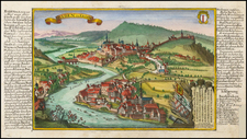
![[Geneva] Vedendo quanto il mondo sia hoggi di curioso di veder il sito e form di Ginerva . . . M.D.LXVII.](https://storage.googleapis.com/raremaps/img/small/76063.jpg)
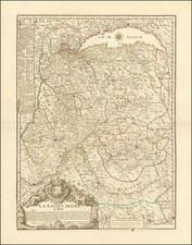
![[Lake Neuchâtel]](https://storage.googleapis.com/raremaps/img/small/73670.jpg)
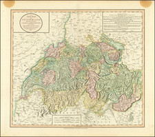
![[Switzerland] Charte de la Suisse, de la Rhetie, ou des Grisons, de la Valtelin, du Valay, & autres Seigneuries Voisines Exactement dressee sur les Lieux par Gaspr Baudouin Ingenieur Militaire & Capitaine de l'artillerie du Roy . . . en L'Estat de Millan](https://storage.googleapis.com/raremaps/img/small/91530.jpg)