|
||

|

|
|

|
Stock# 95431
Description
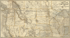
Important early map of Minnesota Territory, including all of Dakota, from an early edition of Mitchell's Universal Atlas.
One of the earliest editions of the map, first issued in 1850, the year after Minnesota became a territory. Massive Pembina and Dacotah counties in the west , with many Indian Tribes, forts and other early exploration notes shown.
The map is based largely on the works of Nicollet and Pope, and includes extensive notes on early exploration and topography throughout.
An essential map for Minnesota and Dakota collectors.
Condition Description
Toned, with minor chip in lower left margin and trimmed margins.