


|
||

|

|
|

|
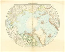
Pioneering Map of the South Seas by the Scottish National Antarctic Expedition.
The most detailed and scientific map of the seafloor of the Southern Ocean to date, published following the return of the famed Scottish National Antarctic Expedition.
The importance of a detailed understanding of the seafloor of the South Sea was outlined by John Murray in an 1894 article calling for a renewed exploration of Antarctica. Drawing on two earlier expeditions that had initialized this field, namely the Ross and Challenger expeditions, he suggested both how the depth of seafloor and the extent of terrigenous deposits may improve our understanding of the continental nature of Antarctica. At that time, the size of Antarctica was still debated, and the extent of continental debris found at the seafloor was proposed as a possible proxy for the land extent of that continent.
The Scottish National Antarctic Expedition sought to both improve the knowledge of this variable as well as make additional measurements, and stored thousands of feet of cable in custom-built spools onboard the vessel to do so. By also distinguishing between the different types of microbial oozes found at the seafloor, and whether the foraminifera were calcareous, they were able to better constrain the chemistry of the oceans. This represented an early form of climate science.
The map was published in a 1905 issue of the Scottish Geographical Magazine.
The Scottish National Antarctic Expedition
Described as "by far the most cost-effective . . . scientific expedition of the Heroic Age," the Scottish National Antarctic Expedition represented at once an attempt to push the boundaries of science and Scottish nationalism. The expedition was led by William Speirs Bruce and was a groundbreaking venture that took place from 1902 to 1904. Bruce, a Scottish naturalist and oceanographer, aimed to conduct comprehensive meteorological, oceanographic, and biological research in the Antarctic region. The expedition ship, the Scotia, was specially modified to withstand the harsh Antarctic conditions. Over the course of the expedition, the team discovered new land—later named Coats Land—in honor of the expedition's primary financial backers, and conducted extensive marine biological studies, collecting thousands of specimens. The data gathered during this expedition significantly contributed to the field of polar science and laid the groundwork for future Antarctic research.
The expedition was also a point of national pride for Scotland, which was often overshadowed by larger British expeditions. Bruce's meticulous planning and focus on scientific inquiry set a precedent for how Antarctic expeditions should be conducted. Despite facing financial constraints and receiving little government support, the expedition was deemed a success both scientifically and logistically. The findings were published in a six-volume work, which remains an important resource in polar studies. Moreover, the expedition established the first permanent weather station in the Antarctic, which provided valuable long-term climate data.
The expedition set sail from Troon, Scotland, on November 2, 1902, aboard the Scotia, making its way southward through the Atlantic. After a brief stop in Buenos Aires, Argentina, for final preparations and resupply, the expedition reached the South Orkney Islands in February 1903. Here, they conducted extensive scientific observations and even established a meteorological station, which Argentina later took over and continues to operate to this day. The expedition then ventured further south, discovering new territory—Coats Land—before ice conditions forced them to turn back. The Scotia overwintered in the Falkland Islands, allowing the team to sort through their findings and make necessary repairs to the ship. In November 1903, they embarked on their second Antarctic season, focusing on marine biology and oceanography. By July 1904, the expedition returned to Scotland, marking the end of a journey that had lasted nearly two years.
Rarity
We are unable to trace any further examples of this map having been offered for sale.
![[The Northern and Southern Skies] Hemisphaerii Borealis Coeli et Terrae Sphaerica Scenographia (and) Haemisphaerium Scenographicum Australe Coeli Stellati et Terrae](https://storage.googleapis.com/raremaps/img/small/78919.jpg)
![[SAS -- Polar Airline Route]](https://storage.googleapis.com/raremaps/img/small/71578.jpg)
![[ Eastern Hemisphere Globe Gores. ] (Nova et integra universi Orbis descriptio)](https://storage.googleapis.com/raremaps/img/small/54480.jpg)