|
||

|

|
|

|
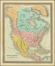
Rare separately published map of North America, published by Hocquart in 1838.
The primary map illustrates the evolving understanding of North America's cartographic features west of the Mississippi River. The boundary shown is drawn from the Adams-Onis Treaty of 1819. Texas and Nouvelle California are part of the newly independent Mexico. The Buenaventura River and Miller's River, a misinterpreted San Joaquin River, are shown extending from the area around Valle Salado (Salt lake Valley) to the Pacific. On the southwest coast of Florida is Punta Tancha, or Sable (or Sandy) Point. The Republic of Texas, not recognized by Mexico, does not appear as a sovereign state. Santa Fe is shown as a seat of government. Le Cap (or Cap-Haïtien) and Port au Prince are both seats in Haiti. Quebec City is the capital of the Province of Canada.
In Oregon Territory (District de Columbia on the map), Ft. Astoria is shown, as is Fort D. Dougal (Fort Umpquah), which had just been established at the confluence of Calapooya Creek and the Umpqua River in 1832. A number of other forts (Hudson Bay Company and American) appear further north. In the Columbia district, the border between the United States and Canada is undefined from the Pacific to the Rocky Mountains. Greenland is bisected by a strait from Foster Bay west to Baffin Bay.
Includes 5 inset maps:
- Russian Alaska and vicinity
- Jamaica
- Cuba, Bahamas, and South Florida
- Bahamas and Hispaniola
- Puerto Rico and the Windward and Leeward Islands
Rarity
This is only the second example we have seen of this map.
![L'Amerique Septentrionale qui fait partie des Indes Occidentales... [with] Description Abrege de L'Amerique Septentrionale](https://storage.googleapis.com/raremaps/img/small/99762.jpg)
![(North America) ФИЗИЧЕСКАЯ КАРТА СEВЕРНОЙ АМЕРИКИ. [Physical Map of North America]](https://storage.googleapis.com/raremaps/img/small/90262.jpg)