|
||

|

|
|

|
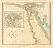
Created by Aaron Arrowsmith and published in 1802, the Plan of the Operations of the British & Ottoman Forces in Egypt, From the 8th of March to the 2d of Septr. 1801 provides a highly detailed account of the British and Ottoman campaign to expel French forces from Egypt. A noted British cartographer of the time, Arrowsmith based this battle plan on information gathered from the Quarter Master Generals Department, ensuring a high degree of accuracy and detail. This map focuses on the Nile River and its delta, starting just south of Cairo and extending northward.
One unusual feature of the map is a note indicating the "ANTIENT Bed of the LAKE MAREOTIS," a body of water south and west of Alexandria. The note mentions the lake was flooded by the British after the Battle of Alexandria, extending it for fifty leagues to the west, making it "the most Magnificient piece of Water ever formed by Artificial Means."
Additionally, there is an inset on the left side of the map showing a strip of land that includes Alexandria, with Lake Mareotis on one side and the Mediterranean Sea on the other. This precise detailing provides critical insights into the geographical context in which these historic military operations took place.
The British and Ottoman campaign depicted in this map took place during the larger context of the Napoleonic Wars. Napoleon Bonaparte had invaded Egypt in 1798, aiming to disrupt British trade routes with India and establish French influence in the region. The French occupation of Egypt, however, faced significant opposition, culminating in the expulsion of French forces in 1801, as depicted in Arrowsmith's map. This map, thus, serves as an important historical document, visually encapsulating a pivotal chapter in the intricate military and political dance of the early 19th century.
The Arrowsmiths were a cartographic dynasty which operated from the late-eighteenth century to the mid-nineteenth. The family business was founded by Aaron Arrowsmith (1750-1823), who was renowned for carefully prepared and meticulously updated maps, globes, and charts. He created many maps that covered multiple sheets and which were massive in total size. His spare yet exacting style was recognized around the world and mapmakers from other countries, especially the young country of the United States, sought his maps and charts as exemplars for their own work.
Aaron Arrowsmith was born in County Durham in 1750. He came to London for work around 1770, where he found employment as a surveyor for the city’s mapmakers. By 1790, he had set up his own shop which specialized in general charts. Arrowsmith had five premises in his career, most of which were located on or near Soho Square, a neighborhood the led him to rub shoulders with the likes of Joseph Banks, the naturalist, and Matthew Flinders, the hydrographer.
Through his business ties and employment at the Hydrographic Office, Arrowsmith made other important relationships with Alexander Dalrymple, the Hudson’s Bay Company, and others entities. In 1810 he became Hydrographer to the Prince of Wales and, in 1820, Hydrographer to the King.
Aaron Arrowsmith died in 1823, whereby the business and title of Hydrographer to the King passed to his sons, Aaron and Samuel, and, later, his nephew, John. Aaron Jr. (1802-1854) was a founder member of the Royal Geographical Society (RGS) and left the family business in 1832; instead, he enrolled at Oxford to study to become a minister. Samuel (1805-1839) joined Aaron as a partner in the business and they traded together until Aaron left for the ministry. Samuel died at age 34 in 1839; his brother presided over his funeral. The remaining stock and copper plates were bought at auction by John Arrowsmith, their cousin.
John (1790-1873) operated his own independent business after his uncle, Aaron Arrowsmith Sr., died. After 1839, John moved into the Soho premises of his uncle and cousins. John enjoyed considerable recognition in the geography and exploration community. Like Aaron Jr., John was a founder member of the RGS and would serve as its unofficial cartographer for 43 years. Several geographical features in Australia and Canada are named after him. He carried the title Hydrographer to Queen Victoria. He died in 1873 and the majority of his stock was eventually bought by Edward Stanford, who co-founded Stanford’s map shop, which is still open in Covent Garden, London today.
![[ Cairo ] Warhaffte abcontrafehtung der machtigen und vesten Statt Alkair](https://storage.googleapis.com/raremaps/img/small/87984.jpg)
![[With Early Annotations!] Nuova et Copiosa Descrittione Di Tutto L'Egitto Pur hora de Paulo Forlani Veronese intagliata in Venetia lanno 1566](https://storage.googleapis.com/raremaps/img/small/75556.jpg)
![Barbaria [with] Cartaginis sive potius Tunetani celeberrimi Sinus nec non fortalitij . . . [with] [Untitled map of Egypt]](https://storage.googleapis.com/raremaps/img/small/72788.jpg)