|
||

|

|
|

|
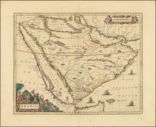
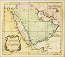
The First State of Francesco Berlinghieri's Rare Map of Arabia.
Showing the Holy Cities of Mecca and Medina and the first faint depictions of Qatar and the United Arab Emirates.
This is Francesco Berlinghieri's extraordinary 1482 Tabula Sexta di Asia, one of the rarest and most desirable early maps of the Arabian Peninsula.
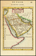
A collector looking to acquire the earliest cartographic representation of Arabia has three options: copperplate engravings produced in Rome (1478 Buckinck & Sweynheim) and Florence (1482 Berlinghieri) and a woodcut map printed in Ulm (1482 Germanus). All three maps have their merits, and the choice may ultimately come down to personal and visual preferences.
What sets the Berlinghieri map apart is the ambition that defined his ground-breaking atlas, Septe Giornate della Geographia. As discussed in more detail below, Berlinghieri was an innovator, employing multiple projections and drawing on unique sources, not just Ptolemy. He was also one of the first cartographers to introduce new, "modern" maps, which would become standard in subsequent atlases. Berlinghieri was cutting-edge, daring to experiment by enhancing the established Ptolemaic model in his maps and text.
Furthermore, Berlinghieri's Arabia map is striking, with a distinct set of underlying artistic principles. Unlike the schematic 1478 Rome or the dense 1482 Ulm Arabia maps, the Berlinghieri Arabia is one of the first printed maps with aesthetic aspirations rather than just representational ones. Its coastlines feel dynamic and alive, its mountains and rivers more fluid.
The Gulf Coast
Berlinghieri's map depicts the entire Arabian Peninsula in a recognizable shape but with a distinctly Ptolemaic configuration. As noted by Arabia map scholar Gerald Tibbetts (1978), Ptolemy exaggerated Eurasia's length to the east. The distance between the Red Sea and Persia was thus too broad, and Arabia was stretched to fill the gap. Because Ptolemy knew the entrances to the Red Sea and Persian Gulf were very narrow, he had to make all the shapes work together.
The distorted shape and ancient toponyms pose a significant challenge to the modern viewer. However, recent scholarship has identified a number of place names that reveal this map as one of the earliest representations of what today constitutes the United Arab Emirates. In Enhanced Mathematical Method for Visualizing Ptolemy's Arabia, the authors attempt to match Ptolemaic place names with modern equivalents. Some relevant examples on Berlinghieri's map include Abu Dhabi (Chabuata - placed far west beneath the label 'MALAGIE'), Jazīrat as Sīnīyah (Casina), and Sharjah (Sacoa).
Looking on the right page of the map, near the center between the 'I' and 'C' in ARABIA FELICE (Arabia Felix), we see a large river labeled Alar Fl. It snakes its way from a central massif to the waters of the Gulf. Gibson initially suggested that this watercourse is Dubai Creek (2013). However, in light of the position of its mouth close to the Strait of Hormuz, the more likely attribution is that the Alar River represents Wadi Lamhah, which runs north through the modern United Arab Emirates and empties into the Gulf just north of Sharjah (Abshire et al. 2020).
Qatar is easier to identify, although its cartographic configuration looks nothing like a modern map. Both Berlinghieri, as well as the Rome 1478 and 1482 Ulm, locate the East Arabian toponym of Catara (Cotara on the Ulm map) slightly inland, at roughly the place where the coastline shifts from a general north-south orientation to a more east-west orientation. In all three maps, most of Arabia's inland centers are directly linked with a port or coastal entrepôt (a phenomenon described in the 2nd-century pilot: Periplus Maris Erythraei). In Catara's case, this coastal hub is a site named Gerra. While the pattern of an inland Catara associated with a coastal Gerra is consistent in 15th-century maps, Berlinghieri places his version of Catara slightly to the north of Gerra, which in turn sits on a shielded bay (created by Berlingheiri's characteristic 'scooped' coastlines).
East-southeast of Catara is Mathala, which recently has been identified as the town of Muzayri in the UAE (south-southwest of modern Abu Dhabi). As an inland town, Mathala is fronted by several toponyms along the coast. Only one of these - Magidanata - has been identified with some certainty. Hamad bin Seray (1997) argues that this is the Saudi coastal town of al-Qatif, which, in reality, is located much further north, beyond the island of Bahrain. If correct, Berlinghieri’s placement of al-Qatif in what we might tentatively define as the United Arab Emirates reflects how unpredictable Ptolemaic maps and coordinates could be.
The Red Sea Coast
Moving west to the Red Sea, as one would expect, Berlinghieri includes the two most famous cities of the Arabian Peninsula: Mecca and Madina.
A sizeable western river, Betio Fl., flows into the Red Sea from a central mountain range. The Betio River figures prominently in Ptolemy and has thus been transposed onto most 15th-century maps of Arabia. Scholarly consensus is that it corresponds to Wadi Fa'idah or Wadi Fayd, a river bed that culminates in the Khawr al-Butan, outside Dahaban, just north of Jedda. Quite far inland, positioned on either side of the Betio, we find the Holy Cities of Islam. To the north is Lathrippa, a Latinised corruption of Yathrib, the pre-Islamic name for the settlement that became Madina. On the other side of the river is Macoraba, which most geographers believe constitutes Mecca.
Historically, both cities were connected to their respective ports on the Red Sea: Mecca to Jeddah and Madina to Yanbu. Even though Jedda was only fully developed into a commercial port after the advent of Islam, it is included on Berlinghieri's map as Badeo Regio (a Greek language corruption of al-Balad, the ancient name for Jedda's old town). While Jedda's position is more or less correct geographically, Madina's harbor of Yanbu (Iabia-Vie on Berlinghieri's map, though commonly named Iambia) has been placed far too north.
Arabia's Center: A Filled Empty Quarter
In their analysis of Arabia on Ptolemaic maps, Abshire and his colleagues convincingly show that Vodona in Central Arabia corresponds to the modern town of Bidbid, located near Nizwa in modern Oman (Abshire et al. 2020). All three Ptolemaic maps position this location erroneously in the interior of the peninsula. In effect, this error and others fill what should be Arabia’s uninhabited center: the enormous Empty Quarter or Rub al-Khali desert. In Berlinghieri's map, this mistake is underscored by the placement of the Yemeni town of Najran (Nagara) to the northeast, conflating the eastern (Oman) and western (Yemen) halves of the southern peninsula.
By Ptolemy's time, Greek sailors had sailed around the Arabian coast and were familiar with its port towns. However, the interior remained largely unmapped until the 20th century. The northern part of the peninsula tended to be mapped more accurately because it was closer to populated lands and more frequently traveled. The cartographic legends of the interior came from stories told by sailors about what lies inland and the desire to fill space, which was common in pre-18th-century cartography.
In this semi-mythological landscape, we note a curious range of elements and features that do not correspond to any known reality. Enormous rivers extend from interior mountain ranges. The map's southern river, labeled Prion Fl. by Berlinghieri and his contemporaries, is most likely a depiction of the mythological Pishon River, one of four rivers associated with the Garden of Eden. Other fascinating features include a string of islands in the Red Sea and what almost amounts to an archipelago around the Strait of Hormuz. Several islands figure to the south of Arabia, including a super-sized Socotra.
Berlinghieri: A Unique Tradition of Cartography
The cartography of Francesco di Niccolo Berlinghieri is viewed as a distinct tradition within the framework of Ptolemaic mapmaking. Most scholars agree that Belinghieri used sources different from his contemporaries to delineate the world's land masses. The configuration of the Mediterranean, in particular, appears to have drawn on alternative sources. A common explanation is that Berlinghieri, as a Fiorentine, had access to far older and more accurate portolan charts and possibly even sources from within the Islamic world. Unfortunately, confirming what those alternative sources might have been remains speculative.
An important distinction between his Ptolemaic atlas and other 15th-century versions was Berlinghieri's deliberate use of the archaic homeotheric or equidistant cylindrical projection, which is attributed to Ptolemy's predecessor and primary source of geographic information: Marinus of Tyre (c.100 CE). As far as we know, Ptolemy never actually made maps himself, so we do not know which projection he favored.
Nevertheless, by the time the first Ptolemaic Geographies were going into print, most mapmakers had shifted to the new trapezoidal projection attributed to German cartographer Donnus Nicolaus (c.1420-1490).
Cartographic scholar Peter Meurer points out that all known Ptolemaic Geographies from the 15th century were built directly on the manuscripts of Donnus Nicolaus but that Nicolaus himself used different projections over time. While the new trapezoidal projection, known as the "Donis-projection," was used in the Rome Ptolemy and the influential maps of Henricus Martellus, the Ulm edition returned to an equidistant cylindrical projection in order to present the new and updated understanding of Scandinavia based on the work of Danish cartographer Claudius Clavus.
Berlinghieri's Septe Giornate is the only 15th-century atlas to use multiple projections depending on what parts of the world were being presented. The creative process behind the Septe Giornate thus differed from that of contemporary Geographies.
States of the map
For a long time, most scholars agreed that much, if not all, of the Septe giornate was completed by 1479, including the maps, which were interpreted as having been printed in a single large batch and then subsequently bound and published in 1482 (Skelton 1966; Campbell 1987). A significant number of extra sheets were left over from the original printing, and after Berlinghieri’s death in 1501, these were purchased and bound into a new edition with a new title page that was issued around 1503-1504.
A new and comprehensive study by Peerlings and Laurentius (2023) has nevertheless managed to identify subtle distinctions in many of Berlingheiri’s maps, denoting that there were amendments made and that different states thus exist.
For Arabia, the authors identify two distinct states. The current example is the first state, confirmed by two features:
-
In the map's upper left-hand corner, we find the words "PAR DE ARABIA PETREA." In the second state, 'PETREA' has been overprinted, making it almost illegible; this is not the case in our example.
-
The other feature to confirm our sheet as an original first state is the word 'SARACENI' found in the northern part of the Arabian desert. In the second state, an additional ‘S’ has been added to the plate above the ‘S’ in 'SARACENI.' Once again, this does not figure in our map, unequivocally confirming its original state.
Mild toning.
Campbell, Tony (1987). The Earliest Printed Maps (1472-1500), British Library: London
Gibson, D. (2013). Suggested Solutions for Issues Concerning the Location of Mecca in Ptolemy’s Geography. Nabatea
Hamad bin Seray (1997). The Arabian Gulf in Syriac Sources. In: New Arabian Studies,Vol. 4. G.R.Smith & B.R. Pridham (eds.). Exeter: Exeter University Press. Pp. 205-232
Helas, Philine. (2002). The "Flying Map" . Le 'Septe Giornate della Geographia', by Franesco Berlinghieri \ dedicated to Federico da Montefeltro and Lorenzo de Medici, and depictions of the world in 15th-century Florence (Cartography). Mitteilungen des Kunsthistorischen Institutes in Florenz 46: 271-320
Peerlings, R.H.J. & F. Laurentius (2023). Berlinghieri’s Geography Unveiled. Freely available at www.berlinghieri.eu
Skelton, R.A. (1966). A bibliographical note prefixed to the facsimile of Berlinghieri’s Geographia, Theatrum Orbis Terrarum: Amsterdam.
Meurer, Peter H. (2007). 42 - Cartography in the German Lands, 1450–1650. In The History of Cartography, Volume 3, Part 2. David Woodward (ed.). Chicago: University of Chicago Press. pp. 1182–1183.
Claudius Ptolemy (fl. AD 127-145) was an ancient geographer, astronomer, and mathematician. He is known today through translations and transcriptions of his work, but little is known about his life besides his residence in Alexandria.
Several of his works are still known today, although they have passed through several alterations and languages over the centuries. The Almagest, in thirteen books, discusses astronomy. It is in the Almagest that Ptolemy postulates his geocentric universe. His geometric ideas are contained in the Analemma, and his optical ideas were presented in five books known as the Optica.
His geographic and cartographic work was immensely influential. In the Planisphaerium, Ptolemy discusses the stereographic projection. Perhaps his best-known work is his Geographia, in eight books. However, Ptolemy’s ideas had been absent from western European intellectual history for roughly a thousand years, although Arab scholars interacted with his ideas from the ninth century onward.
In 1295, a Greek monk found a copy of Geographia in Constantinople; the emperor ordered a copy made and the Greek text began to circulate in eastern Europe. In 1393, a Byzantine diplomat brought a copy of the Geographia to Italy, where it was translated into Latin in 1406 and called the Cosmographia. The manuscript maps were first recorded in 1415. These manuscripts, of which there are over eighty extant today, are the descendants of Ptolemy’s work and a now-lost atlas consisting of a world map and 26 regional maps.
When Ptolemy’s work was re-introduced to Western scholarship, it proved radically influential for the understanding and appearance of maps. Ptolemy employs the concept of a graticule, uses latitude and longitude, and orients his maps to the north—concepts we take for granted today. The Geographia’s text is concerned with three main issues with regard to geography: the size and shape of the earth; map projection, i.e. how to represent the world’s curve proportionally on a plane surface; and the corruption of spatial data as it transfers from source to source. The text also contains instructions as to how to map the world on a globe or a plane surface, complete with the only set of geographic coordinates (8000 toponyms, 6400 with coordinates) to survive from the classical world.
Francesco Berlinghieri (1440-1501) was a Florentine engraver. Nicolas Laurentii published Berlinghieri's edition of Ptolemy, which was written in Italian terza rima, comprising 123 folios of text and 31 engraved maps. The work was first printed in 1482, but most surviving examples come from the edition of 1486, which was the first edition to include red printing in the title page. The full title is Geographia. In Questo Volume Si Congengono Septe Giornate Della Geographia Di Francesco Berlingeri Fiorentino Allo Illustrissimo Federigo Duca . . .
Berlinghieri's edition of Ptolemy is unique, in that it includes 31 maps covering Europe, northern Africa and the south part of Asia and is the first atlas to attempt the introduction of modern geography, with the inclusion of four new maps - France, Italy, Spain and Palestine, which are based on contemporary knowledge. rather than a strict plotting of Ptolemy's coordinates. A number of other maps in the Berlinghieri edition of Ptolemy include data which is drawn from modern sources, albeit more subtlely so, in part because of transcription errors and in part because of corrections made over time by later scholars.
While Berlinghieri's atlas was the third Italian printed edition of Ptolemy, it was very important in other respects. Berlinghieri's Ptolemaic regional maps are drawn on Marinus' plane projection; and although not generally considered an edition of Ptolemy, the maps are the only examples of Ptolemy's maps to be drawn on the original projection, with equidistant meridians and parallels. Berlinghieri's work was also the first to include a printed Gazetteer for each of the maps.
The text by Berlingheiri is a metrical paraphrase of Ptolemy, the first atlas in the Italian language. Francesco Berlinghieri was an Italian scholar and humanisrt. He promoted the value of classical Greek learning and therefore was the first to print an edition of Ptolemy in vernacular Italian, rather than Latin. The maps look distorted as compared to modern maps, because Ptolemy's data was inaccurate. One reason is that Ptolemy estimated the size of the Earth as too small: while Eratosthenes of Cyrene, a Greek mathematician, elegiac poet, athlete, geographer, and astronomer, made several discoveries and inventions including a system of latitude and longitude and conceived the idea of 700 stadia for a degree on the globe, in the Geographia Ptolemy uses 500 stadia. It is not certain if these geographers used the same stadion, but if we assume that they both stuck to the traditional Attic stadion of about 185 meters, then the older estimate is 1/6 too large, and Ptolemy's value is 1/6 too small. Because Ptolemy derived most of his topographic coordinates by converting measured distances to angles, his maps get distorted. So his values for the latitude were in error by up to 2 degrees. For longitude this was even worse, because there was no reliable method to determine geographic longitude.
Ptolemy was well aware of this. It must be added that his original topographic list cannot be reconstructed: the long tables with numbers were transmitted to posterity through copies containing many scribal errors, and people have always been adding or improving the topographic data: this is a testimony to the persistent popularity of this influential work in the history of cartography..
As early as 1938 Arthur M. Hind, Keeper of Prints and Drawings at the British Museum, hinted that the engravings might have been made by Francesco Rosselli (1448-before 1527), the principal engraver in Florence in the 1480s and 1490s. Subsequently, this possibility was rejected by Roberto Almagiagrave, R. A. Skelton and Tony Campbell. In the author's view, however, both stylistic and circumstantial evidence argues that Francesco was indeed the engraver, and that this first major commission launched the career that eventually made him known to his contemporaries as 'Franciscus rosellus florentinus Cosmographus'.