|
||

|

|
|

|
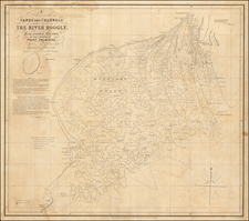
The Coast of India between Calymere and Gordeware Points, including the Coast of Coromandel with part of the Coast of Golconda, was published by the renowned firm of Laurie & Whittle in London, in 1794. This detailed portrayal of the Indian coastline is a crucial artifact for comprehending the navigational and topographical knowledge during the era of the British East India Company's presence in the Indian subcontinent.
In the last decades of the 18th century, the British Empire's commercial and political interest in India was rapidly growing. An increasing demand for exact geographic knowledge drove an unprecedented era of map-making and surveying. Laurie & Whittle, established in 1794, were part of this significant period of cartographic history. Their work, heavily reliant on the diligent surveys conducted by mariners and explorers, contributed to a vast repository of navigational charts and maps. This particular piece, depicting the coastal regions of Calymere, Coromandel, and Golconda, serves as an exemplar of the company's attention to detail and its significant role in charting the Indian subcontinent.
The map's features provide invaluable insight into the understanding of coastal profiles during this period. Detailed annotations offer glimpses into the coastal morphology and navigational landmarks, reflecting the rigorous observational practices employed by the cartographers. The inclusion of named regions like Maravar, Tanjore, Coromandel, and Golconda showcases the cartographers' in-depth knowledge of the region's geography and the British administrative divisions of the time.
Furthermore, the map’s depiction of Palk's Straits and the northern tip of Sri Lanka illuminates the strategic maritime significance these regions held. This focus reflects the burgeoning maritime trade routes that were shaping global commerce in the late 18th century. In particular, the British East India Company's reliance on these routes for the efficient transportation of goods highlights the vital role that detailed navigational charts such as this played in underpinning the commercial enterprises of the era.
With its rigorous attention to detail and historical significance, The Coast of India between Calymere and Gordeware Points, including the Coast of Coromandel with part of the Coast of Golconda, stands as an invaluable artifact of 18th-century British cartography. The map offers not just a geographic portrayal of a significant portion of the Indian subcontinent, but also a window into the period's maritime practices, commercial routes, and colonial interests.
Robert Laurie (ca. 1755-1836) and James Whittle (1757-1818) formed their Fleet Street, London-based firm upon the 1794 death of their employer Robert Sayer, himself one of the dominant print and mapmakers of the last half of the 18th century.
Laurie & Whittle started managing Sayer's business as early as 1787. They took over all managerial duties when Sayer's health flagged in 1792, and they changed the imprint in 1794 upon his death. Sayer left the two a 21-year lease on the shop (at £100 a year) and on Sayer's Bolt Court premises, as well as an option to acquire stock and equipment at a preferential price of £5,000 payable over three years.
Robert Laurie retired from the firm in 1812, and his role was assumed by his son, Richard Holmes Laurie (1777-1858). The younger Laurie worked with James Whittle until the latter died in 1818. After R. H. Laurie died in 1858, Alexander George Findlay, FRGS (1812-1875) purchased the firm from his daughters. The firm continues today under another name, specializing in yachting charts.
Laurie & Whittle were prolific print and map publishers, and throughout their careers, they produced numerous very important and rare works. They carried on Robert Sayer's atlas business and were responsible for editions of The Complete East-India Pilot and The American Atlas.
![[Puducherry-- Hand Drawn Map] Plan de la Ville de Pondichery. Legende des Rues de la ville blanche et de la ville noire de Pondichery avec les numeros d'ordre correspondant a ceux du plan que Mr. le Gouvernor a approuve le Mai 1856](https://storage.googleapis.com/raremaps/img/small/58607.jpg)