|
||

|

|
|

|
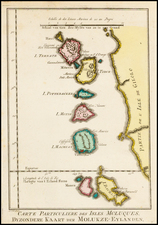
Published by Laurie & Whittle on 12 May 1794, "Several Appearances of Hogs Island on the Western Coast of Sumatra" provides an intricate depiction of the maritime landscapes surrounding Hogs Island (present-day Simeulue), off Sumatra's western coast. The plate features six distinct coastal profiles, each recorded meticulously, demonstrating a compelling application of 18th-century coastal cartography.
The art of rendering coastal profiles or coastal views, common during the 18th century, was crucial for seafarers. These illustrations allowed mariners to recognize landforms as they appeared from a ship's deck, thereby aiding navigation. The recorded appearances in this particular map range from the little island to the south-southeast of Hogs Island, viewed from different angles and distances, to parts of Simeulue itself and a section of Sumatra's west coast.
Each coastal profile captures a unique perspective of the island. The distances from which the views are observed—ranging from 4 to 12 leagues—emphasize the varying scales of observation that the mariners would have engaged with during their voyages. The directions provided further enhance this by offering an understanding of the relative orientation of the islands.
The plate's coastal profiles exhibit the stark features of Hogs Island and its surrounding areas, revealing the contours, vegetation, and topography that make this part of Sumatra unique. This depiction of the western coast of Sumatra was created at a time when maritime exploration was opening up the vast and diverse landscapes of the East Indies to European understanding.
Robert Laurie (ca. 1755-1836) and James Whittle (1757-1818) formed their Fleet Street, London-based firm upon the 1794 death of their employer Robert Sayer, himself one of the dominant print and mapmakers of the last half of the 18th century.
Laurie & Whittle started managing Sayer's business as early as 1787. They took over all managerial duties when Sayer's health flagged in 1792, and they changed the imprint in 1794 upon his death. Sayer left the two a 21-year lease on the shop (at £100 a year) and on Sayer's Bolt Court premises, as well as an option to acquire stock and equipment at a preferential price of £5,000 payable over three years.
Robert Laurie retired from the firm in 1812, and his role was assumed by his son, Richard Holmes Laurie (1777-1858). The younger Laurie worked with James Whittle until the latter died in 1818. After R. H. Laurie died in 1858, Alexander George Findlay, FRGS (1812-1875) purchased the firm from his daughters. The firm continues today under another name, specializing in yachting charts.
Laurie & Whittle were prolific print and map publishers, and throughout their careers, they produced numerous very important and rare works. They carried on Robert Sayer's atlas business and were responsible for editions of The Complete East-India Pilot and The American Atlas.
![[ Jakarta to Bangka ] A New Chart for Sailing Between The Straits of Sunda or Batavia, and the Straits of Banca and Gaspar . . . 1794](https://storage.googleapis.com/raremaps/img/small/95486.jpg)
![S.E. Peninsula and Malaysia [Singapore inset and Pulo Penang or Price of Wales Island inset]](https://storage.googleapis.com/raremaps/img/small/103012.jpg)