|
||

|

|
|

|
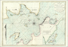
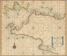
This 18th-century maritime chart represents the Port of Rhio on Bintan Island, located within the strategic Singapore Straits. Published by the firm of Laurie & Whittle, the chart offers a meticulous representation of Bintan and the neighboring Batam Island, both parts of the Riau Archipelago and today recognized as popular resort destinations in Southeast Asia.
The islands, conveniently situated along the southern edge of the Singapore Straits, form a crucial passage connecting the Indian and Pacific Oceans. The prime harbor on Bintan, 'Rhio' (presently known as Bintang Bay), has been a significant trading port since the 3rd century A.D. Between 1200 and 1500, it served as the principal base for Malay pirates operating in the straits. With the fall of Malacca to the Portuguese in 1511, Bintan became the capital of the influential Johor Sultanate. The chart dates back to the 18th century when British influence dominated the Riau Archipelago, although the local sultan managed daily affairs. The archipelago did not become a part of the Dutch East Indies until the signing of the Anglo-Dutch Treaty in 1824.
The chart provides a detailed hydrographic survey of Bintan Bay, portraying the routes of the ships that charted the harbor during the 1750s. Of particular note are socio-demographic details provided around the town of Rhio, with the 'King's [Sultan's] Palace', the 'Chinese compound', the 'Malay Compound', and the 'Fishing Town' (inhabited by the Bugis) distinctly labeled. The 'Fishing Village' on Batam Island also features in the chart.
A reference section informs sailors of potential hazards and landmarks, such as a bank of rocks and sand known to be dangerous ('A'), a precarious point with an uneven bottom which becomes dry at low tide ('B'), and a bank with two rocks always above water ('C'). A note about the current in the region ('EEE') and directions for vigilance are also given, guiding vessels safely through the straits.
Thus, this 18th-century chart served as an essential navigational guide for seafarers navigating the bustling Singapore Straits, offering intricate topographical and sociocultural insights about the region.
Richard Holmes Laurie (1777-1858) was the son of mezzotint engraver Robert Laurie, who had taken over Robert Sayer's publishing house with James Whittle in 1794. Richard Holmes Laurie joined in a partnership with Whittle when his father retired in 1812. The name of the firm then switched from Laurie & Whittle to Whittle & Laurie. Whittle died in 1818, leaving Richard Holmes to continue publishing alone as R. H. Laurie.
When the Hydrographic Office opened in 1795, it was tasked with creating and producing all the nautical charts for the Royal Navy so as to wean the Navy off dependence on foreign charts. By the 1820s, private publishers were augmenting HO charts and competing with them, including Richard Holmes Laurie. Richard gave up publishing anything except nautical materials by 1830. He also sold charts to Trinity House, the lighthouse and maritime safety fraternity. He died in 1858.
The firm continued to print under the name R.H. Laurie even after 1858. Later, the firm was managed by Laurie’s draughtsman, Alexander George Findlay, and, later, Daniel and William Kettle.
James Whittle (1757-1818) was a British engraver and map printer. Whittle was employed by Robert Sayer (ca. 1725-1794). Together with Robert Laurie (1755?-1836), he took on Sayer’s business when the older man died in 1794. The two traded together as Laurie & Whittle until 1812, when Laurie retired. They had specialized in sea charts and maritime atlases. Whittle then partnered with Laurie’s son, Richard Holmes Laurie, until he died in 1818.
![[ Bangka Strait ] Plan of the Straits of Banca Surveyed by Captn. Lloyd of the Elliot Country Ship and Mr. Bampton in his Passage from China to Batavia and from Batavia to Malaca . . . 1796](https://storage.googleapis.com/raremaps/img/small/94800.jpg)