


|
||

|

|
|

|
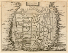
A Chart of the South Part of Sumatra and of the Straits of Sunda and Banca, published in 1794 by Laurie & Whittle in London, provides a comprehensive maritime view of southern Sumatra, western Java, and surrounding islands, enhancing its precision with an expansive inset detailing the Straits of Sunda. This chart not only epitomizes the cartographic detail of its era but also underscores the navigational complexities surrounding the islands and straits, evidenced by the intensive soundings, sailing channels, and profile views.
In the late 18th century, the Sunda Strait, a vital waterway separating the islands of Java and Sumatra in present-day Indonesia, held considerable geopolitical significance. The strait formed a critical passage linking the Indian Ocean to the South China Sea, thereby acting as a nexus for east-west maritime trade routes. European colonial powers, especially the British and the Dutch, had burgeoning economic interests in the East Indies, and controlling or accessing the Sunda Strait meant having a strategic advantage in navigation, commerce, and territorial influence. The spice trade, which had propelled European exploration and colonization in the region, was still influential, and the strait became a focal point for maritime endeavors, including trade in spices, textiles, and other valuable commodities. Moreover, the strait's importance was magnified due to its proximity to other strategic passages, like the Straits of Malacca. Consequently, maritime charts of the Sunda Strait, detailing its navigational intricacies, became invaluable assets, reflecting the broader geopolitical contest in the region.
Robert Laurie (ca. 1755-1836) and James Whittle (1757-1818) formed their Fleet Street, London-based firm upon the 1794 death of their employer Robert Sayer, himself one of the dominant print and mapmakers of the last half of the 18th century.
Laurie & Whittle started managing Sayer's business as early as 1787. They took over all managerial duties when Sayer's health flagged in 1792, and they changed the imprint in 1794 upon his death. Sayer left the two a 21-year lease on the shop (at £100 a year) and on Sayer's Bolt Court premises, as well as an option to acquire stock and equipment at a preferential price of £5,000 payable over three years.
Robert Laurie retired from the firm in 1812, and his role was assumed by his son, Richard Holmes Laurie (1777-1858). The younger Laurie worked with James Whittle until the latter died in 1818. After R. H. Laurie died in 1858, Alexander George Findlay, FRGS (1812-1875) purchased the firm from his daughters. The firm continues today under another name, specializing in yachting charts.
Laurie & Whittle were prolific print and map publishers, and throughout their careers, they produced numerous very important and rare works. They carried on Robert Sayer's atlas business and were responsible for editions of The Complete East-India Pilot and The American Atlas.
![[Signed Political Satire Artwork] Vietnam ... Vietnam ... Vietnam ...](https://storage.googleapis.com/raremaps/img/small/68726.jpg)
![[Southeast Asia, Philippines & India] Nova Delineatio particularis Apostolicarum Peregrinationum noni Indiarum Apostoli in India Orientali](https://storage.googleapis.com/raremaps/img/small/51679.jpg)