|
||

|

|
|

|
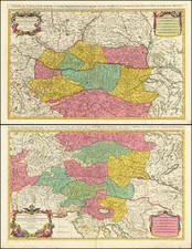
Fine example of Conrad Lotter's well executed map of the Principatus and Archiepiscopatus of Salzburg, offering an exceptional overview of the region.
Central to this view is the Salzach River, connecting the various towns and cities dotted along its banks. The map provides a comprehensive visualization of cities, lakes, mountains, and rivers in the region. Bridges are noticeably marked, highlighting the significant human engineering feats of the time.
During the 18th century, Salzburg was known for its prosperity and expansion, greatly due to its thriving salt mining industry. Salt, often referred to as "white gold," played a significant role in shaping the region's economy and lifestyle. The Vice Dominant of Salzburg, a subsidiary region within the map, highlights this aspect.
The main cities depicted in the map carry their unique historical contexts. Salzburg, as the Prince-Archbishop's residence, was a center of political and religious activity. The map also covers quieter settlements such as Friesach and Strasburg on the Gurk River and the town of Sankt Andre on the Lavant River. Friesach, with its old walls and fortifications, represents the region's medieval history, while Sankt Andre provides a glimpse into the rural life of the 18th century.
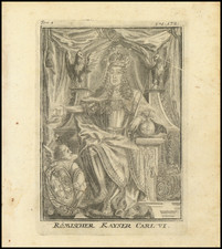
One striking feature of the map is a large cartouche depicting a globe with Salzburg at its center. Cherubs are seen holding a chain of coats of arms, symbolizing various entities associated with the region. Among these coats of arms, one is a portrait of a monarch, likely representing the Habsburgs, who had significant influence in Salzburg during the 18th century.
The map includes a remarkably comprehensive set of symbols, which include:
- Erzbisch. Resid. - Archbishop's Residence
- STÄTT - Cities
- Marcke - Markets
- Hof Marck - Court Market
- Schlößer - Castles
- Dörfer - Villages
- Gepfarrte Dorfer - Parished Villages
- Paß durchs Geburg - Pass through the Mountains
- Bischofft. Universitat - Bishop's University
- Cl. Cong. Bened Salisb. v. Poft Weege - Clerical Congregation of Benedictine Salzburg, possibly related to post routes
- Andere Closter - Other Monasteries
- Marianisch Wallf - Marian Pilgrimage
- Andere Wallfahrte - Other Pilgrimages
- Holtzrechen - Wood Rake (possibly related to forested areas)
- Bergwerck - Mines
- Gold - Gold
- Silber - Silver
- Kupfer - Copper
- Eifen - Iron
- Bley - Lead
- Schwefe - Sulphur
- Stahl - Steel
- Queksilber Vitriol. Galmay - Mercury. Vitriol. Zinc.
- Schmeltzwerck - Smelter
- Hamerwerck - Hammer Mill
- Salz - Salt
- Pflegen - Care, possibly relating to a hospice or nursing institution
- Land Gericht - Local Court
- Poft Abwechsl - Post Exchange
- Landfraßen - Highways or Main Roads
- Pruggen - Bridges
Tobias Conrad Lotter (1717-1777) is one of the best-known German mapmakers of the eighteenth century. He engraved many of the maps published by Matthaus Seutter, to whose daughter Lotter was married. He took over Seutter’s business in 1756. Lotter’s son, M. A. Lotter, succeeded his father in the business.
![[ Holy Roman Empire ] Nova Totius Germaniae Descriptio Geographica](https://storage.googleapis.com/raremaps/img/small/95672.jpg)
![[ Holy Roman Empire, Poland, Baltic, etc. ] Germania VI Nova Tabula (First state!)](https://storage.googleapis.com/raremaps/img/small/94645.jpg)