|
||

|

|
|

|
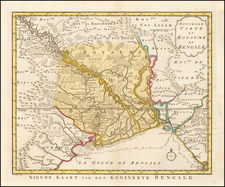
"A New Chart of the Gulf or Bay of Bengal" is an extensive sea chart published by Laurie & Whittle in 1797, detailing the Bay of Bengal, from the Coromandel Coast and Ceylon (present-day Sri Lanka), to the Straits of Malacca. The southern boundary of the map stops at the Equator, with a notation regarding "Ouro Island of the Compton in 1728 according to some."
The map features three insets detailing more localized regions: "The River Sirian" as delineated by D'Anville, "The River of Perseen" as surveyed by Capt. Hayter, and a chart of "Isle St Mathew and the Adjacent Archipelago" as charted by Capt. Thomas Forrest in 1783.
Noteworthy is an extensive passage that provides "Observations of Capt. Hicks on the Track of the Ship Bahar from Madras to Bengal in the Contrary Monsoon." This note provides a detailed account of the Bahar's journey, beginning on October 27, 1770, and arriving in Balafore Road on November 25 of the same year. This observation offers a deep look into the sailing conditions and navigational tactics employed during the late 18th century. It emphasizes the importance of understanding monsoons, prevailing winds, and ocean currents in successfully navigating these waters, and how one might be obliged to cross the Equator to run down the Easting depending on the season. These detailed annotations offer valuable insights to the mariners charting these waters, revealing the dynamic interplay between seafaring, navigation, and climatology during this period.
Robert Laurie (ca. 1755-1836) and James Whittle (1757-1818) formed their Fleet Street, London-based firm upon the 1794 death of their employer Robert Sayer, himself one of the dominant print and mapmakers of the last half of the 18th century.
Laurie & Whittle started managing Sayer's business as early as 1787. They took over all managerial duties when Sayer's health flagged in 1792, and they changed the imprint in 1794 upon his death. Sayer left the two a 21-year lease on the shop (at £100 a year) and on Sayer's Bolt Court premises, as well as an option to acquire stock and equipment at a preferential price of £5,000 payable over three years.
Robert Laurie retired from the firm in 1812, and his role was assumed by his son, Richard Holmes Laurie (1777-1858). The younger Laurie worked with James Whittle until the latter died in 1818. After R. H. Laurie died in 1858, Alexander George Findlay, FRGS (1812-1875) purchased the firm from his daughters. The firm continues today under another name, specializing in yachting charts.
Laurie & Whittle were prolific print and map publishers, and throughout their careers, they produced numerous very important and rare works. They carried on Robert Sayer's atlas business and were responsible for editions of The Complete East-India Pilot and The American Atlas.


![Tabula Asiae XI [Southeast Asia]](https://storage.googleapis.com/raremaps/img/small/95794.jpg)