|
||

|

|
|

|
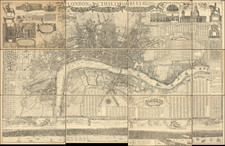
Nice example of this multi-sectional strip map of the Thames River, coveering the river from above Cricklade to London Bridge.
The map shows infrastructure details, such as locks, bridges, and railway lines, and further embellished with information on toll charges, angling regulations, weirs, bathing locations, towpaths, ferries, water mills, and varieties of fish present in the waterway.
This edition represents a continuation of the original map, first conceived in 1861 for James Reynolds by Ernest George Ravenstein (1834-1913). Ravenstein, a geographer and cartographer of German descent, gained notoriety in 1872 when he declined the position of chief cartographer at the Royal Geographical Society on the grounds that the institution would not permit him to smoke within its premises.
![[ London ] Londres](https://storage.googleapis.com/raremaps/img/small/101851.jpg)