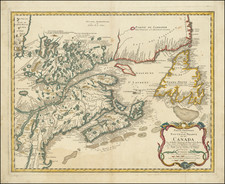
Eastern part of Visscher's 2-sheet map Canada to the Carolinas and the Ohio Valley, first published in 1689
.
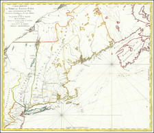
This is probably the most important and interesting state of the map. Not only has Cape Breton been re-engraved and had several place names added, but it is the only state to include a detailed plan of Louisbourg, with the Fort, fortifications, and a legend detailing the batteries of cannon, etc. .
Referring to the first edition of the map, The Maryland Historical Society Huntingfield Map Collection catalog description states:
This beautiful map . . . is probably the most detailed delineatio of the Coastline from the Carolinas to Labrador drawn in the 17th Century. . . . The Cartography of the Atlantic Seacoast is exceptional for the period, but the representation of the interior is almost entirely conjectural. The Del-Mar-Va peninsula is shown in a distinctive shape, with the portion south of Delaware BAy too wide and curving to the east. The map is important to a Maryland-Chesapeake collection primariy because it as later copied by Johann Baptiste Homann in the Maryland-Delmarva Peninsula area . . .
It was in 1745, that William Pepperell and his New Englanders, supported by a fleet of merchant seamen under Sir Peter Warren, attacked and captured the Fort. Three years later the Treaty of Aix-la-Chapelle gave it back to France, but it fell again in 1758 to General Jeffrey Amherst and Admiral Boscawen during the Seven Years' War, and was at that point destroyed.
![[New England] Tierra Nueva](https://storage.googleapis.com/raremaps/img/small/64626.jpg)
![[ Queen Anne's War - Failed Attack on French Canada -- Petition to Queen Anne from the Colony of New York seeking reimbursement for a failed conquest of New France during Queen Anne's War ] To the Queens most Excellent Majesty . . . 1709](https://storage.googleapis.com/raremaps/img/small/85409.jpg)