|
||

|

|
|

|
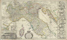
Battle Positions on Lago Maggiore and Ticino River During The War of Austrian Succession
Finely executed map of the area around the Ticino River and the Naviglio Grande from the south end of Lago Maggiore to the area near Vigevano and Motta Visconti.
Oriented with east at the top, the map covers approximately 70 kilometers (43 miles) of the Ticino River, to is split with the Naviglio Grande at Tornavento. Thereafter, the course of the two waterways are shown, as is the course of the Mora Canal flowing past Novara, a historic waterway built by Ludovico il Moro in the 15th century. At the far left (north), the towns of Anghera, Arona, Bruschera, and Lisanza, are shown, along with several smaller villages. The Ticino River, Navigalio Grande and Mora Canal, along with a series or roads are shown extending southward to Motta Visconti and Vigevano.
At the top left, a key locates a number of military positions on either side of the Ticino River, with various commanding officers named. The map includes extraordinary detail, locating the positions of showing the positions of the French and Spanish positions, along with the neighboring towns, roads, castles, islands, bridges and a host of other fine details.
The line shown would become historically important. On September 13, 1746, Charles Emmanuel III of Sardinia, Maria Theresa and Britain agreed the Treaty of Worms, intended to expel Spain from Italy. In return for Sardinian support in Lombardy, the Austrians ceded all their territories west of the Ticino River and Lake Maggiore, along with lands south of the Po River. In return, Charles Emmanuel renounced his claim to the strategic Duchy of Milan, guaranteed the Pragmatic Sanction, and provided 40,000 troops, paid for by Britain.
![[Central Italy & Corsica]](https://storage.googleapis.com/raremaps/img/small/75104.jpg)
![[Lazio / Rome]. Latium nunc Campagna di Roma](https://storage.googleapis.com/raremaps/img/small/89659.jpg)