|
||

|

|
|

|
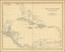
The Gulf of Mexico as Charted by Spain’s Hydrographic Office
Fine, high-resolution chart of the Gulf of Mexico. This chart, issued by the Dirección de Hidrografía, is very rare. This is the first time we have offered this state and this chart.
This is an updated state of the second chart in a series of Spanish naval charts of the region. The first was originally published in 1799 and the second in 1808. The plate for this second chart was subsequently used until the 1840s, being heavily revised at least twice. Here, we see it with additions to 1814, as indicated in the title, and with other changes dating to 1818.
The initial chart was foundational for the mapping of Texas and the US Gulf Coast. It remained of supreme importance and relevance for several decades. Both Humboldt and Arrowsmith copied the information from that chart for their own important maps.
This chart is framed on the Gulf of Mexico, but includes more Caribbean and Atlantic islands than the earliest chart in the series. The Yucatan Peninsula is prominent, as is Florida. The coastlines are extremely detailed, with the exception of only a small part of the northwestern peninsular coast of Florida. The Caribbean is shown out to the western half of Puerto Rico.
New Orleans is tucked inland, with the winding Mississippi passing through. The Mexican coast is studded with mountains visible from the water. A sliver of the Pacific is included, south of Guaxaca or Oaxaca.
The waters are filled with soundings and notes of obstructions that are vital to successful navigation. Many of these are labeled with the year of their sightings, like the rocks near the Yucatan Peninsula seen in 1789, 1817, and 1808 and 1818.
Not all of these obstructions are verified. Several are marked with dotted lines, indicating that their existence is doubtful, or dudoso. Examples of these are the Cascabel and the Comboy near the southern border of the chart. The latter was explored by the Alerta and the Empresa in 1804, as explained in the key in the interior of North America.
Also tucked into the interior are two insets. These show Aguadilla in Puerto Rico and Alacran. The former is a port on the northwest corner of Puerto Rico. The latter is a series of tiny islands near the Yucatan. The Aguadilla inset is new to this chart in the series.
The Evia Survey
One of the most important parts of this chart and its earlier iterations is the portrayal of what is the today the US Gulf Coast—the 1799 first state was the first map to show Galveston, Texas. While this portion of the chart was improved upon between states, its core remains a survey performed under the supervision of Señor Don Juan de Langara, a prominent naval officer. The son of an admiral, he entered the Spanish Navy in 1750 at the age of fourteen. He turned to surveying and exploratory missions from 1766-1771, with three voyages to the Philippines and the seas around China. On his 1771-3 voyage, he, along with José de Mazarredo used the lunar distance method for the first time aboard a Spanish ship. These voyages solidified his reputation as a skilled pilot and surveyor. After decades as a naval minister and distinguished commander, in 1796 he was named Secretary of State for the Navy and a Counsellor of State. A year later, he was appointed Inspector-General for the Navy. He retired in 1799.
Langara was serving in his first stint as a naval minister when this survey was undertaken. In 1777, Lieutenant John Osborn, with John Payne, companions of Admiralty Surveyor George Gauld, surveyed along the Texas coast just west of Galveston Bay. This alarmed Louisiana Governor Bernardo de Gálvez Galiardoqui, who sent a ship to intercept Gauld.
Late in 1777, Gálvez sent Luis Antonio Andry to chart the Louisiana and Texas coasts. However, at Matagorda Bay, Karankawas boarded the ship, killed its crew, and burned all of its charts (and the ship).
After the Treaty of Paris in 1783, the Spanish no longer had to worry about the British on the Gulf Coast. Gálvez redoubled his efforts, sending José Antonio de Evia to survey as much of the region as possible. He covered the Florida Keys to Tampico from 1783 to 1786. These surveys resulted in this chart, among others.
States of the chart
The initial chart in this series was issued in 1799.
The second chart appeared in 1808 with the expanded eastern coverage and the inset of Alacran.
This chart is a heavily revised second state of the second chart. It includes additions to 1818, as well as other important changes:
- title moved
- new inset of Aguadilla
- marshes and topographical details removed
- River near Galveston and Bernardo Bays removed
This particular chart continued to have resonance for the Dirección. Interestingly, a manuscript version of the chart survives in the Archivo del Museo Naval de Madrid, with updates to 1846. It retains the same base cartography, suggesting it may have been a sort of padrón real for the Spanish Main. A printed example with updates to 1846 also exists.
Rarity
The chart is extremely rare. We have been unable to locate any examples of this chart being offered for sale in a dealer catalog or at auction.
We note five extant examples: Archivo del Museo Naval de Madrid (1818 state); Museu Marítim de Barcelona (1818 state); Library of Congress (undetermined); Belgian National Library (KBR) (1818 state) and University of Texas at Arlington (1818 state). Because the title is unchanged, it is difficult to determine which states of the map are in which institution.
The Dirección de Hidrografía, or the Directorate of Hydrographic Works, was established in 1797. Its roots were in the Casa de Contratación, founded in 1503 in Sevilla, which housed all the charts of the Spanish Empire and oversaw the creation and maintenance of the padrón real, the official master chart. The Casa, now in Cadiz, was shuttered in 1790, but Spain still needed a hydrographic body. In response, the Dirección was created in 1797. One of its first projects was the publication of charts from the Malaspina Expedition (1789-1794). The Dirección oversaw not only publication, but also surveying. The Dirección was abolished in the early twentieth century, when their work was distributed to other organizations.
![(Texas Itineraries for the Mexican Northern Army) Coleccion de Itinerarios Para Diferentes Puntos de la Republica Mexicana, Formados Por la Seccion de Geografia y Estadistica de la Plana Mayor del Ejercito, Mandada Imprimir por Orden del Supremo Gobierno de 14 de Marzo de 1844 [including:] Itinerario Razonado de la Ciudad de S. Luis Potosí al Rio Sabina por el Saltillo](https://storage.googleapis.com/raremaps/img/small/94663.jpg)

![[ Upper California, Texas and Mexico ] Carte Generale Du Mexique Ed Des Provinces-unies De L'Amerique Central ou Guatemala](https://storage.googleapis.com/raremaps/img/small/81604.jpg)