|
||

|

|
|

|
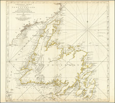
Rare American Published Sea Chart
Detailed sea chart of Maritime, Eastern Canada and New England, published in New York by Blunt.
The map extends inland to Quebec and south to Buzzard's Bay and New Bedford. Includes a large inset of Cape Cod and a large inset of the Gut of Canso, Chedabuctou Bay, etc. The inset of Cape Cod Harbour notes that it is based upon the US Surveys undertaken by Major J.D. Graham of the US Topographical Engineers in 1833, 1834 and 1835, with details on tides, soundings, etc.
A good example of this classic working sea chart. The note to Shipmasters from the Office of the Board of Underwriters reads:
THERE IS REASON TO BELIEVE THAT DISASTERS TO VESSELS have recently occurred on the Southern Coast of the United States in consequence of the use of old and incorrect CHARTS. This Board would earnestly impress upon Ship Masters the great importance of being provided with those that are of recent date and from a reliable source. BLUNT'S CHARTS of the Coast of the United States are corrected in conformity with the Government Surveys, and have accurately laid down the position of all the Lights now in use, or in process of construction on our coast, and these Charts should be familiar to every Ship Master in the trade.
ELLWOOD WALTER, Secretary Board of Underwriters.
Rarity
The chart is quite rare. We locate no examples offered for sale or at auction in RBH or AMPR.
OCLC locates an 1851 edition at the BnF and an 1852 edition at McMaster University.

![[Boston / Anapolis Royal / Plaisance] Plans des Isles, Rades, et Ports de plusieurs Lieuxde l'Amerique Tires de la Carte Angloises de Mr. Popple publiee en 1733 a Londres en Vingt Feuilles.](https://storage.googleapis.com/raremaps/img/small/85117mb.jpg)