|
||

|

|
|

|
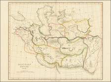
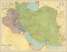
This 1771 map of the Persian Empire is a splendid representation of a significant historical era, detailed and rich with geographical and political information of a region that has been central to human civilization for millennia.
Covering vast territories from the Caspian Sea and Persian Gulf to the territories of modern-day Iran, Iraq, Armenia, and Georgia, the map serves as a historical chronicle as well as a geographical guide. The map displays a myriad of cities, rivers, and topographical features with clear inscriptions. Mountain ranges are shown. The vast, water-filled expanses of the Caspian Sea and the Persian Gulf are prominently detailed, providing testament to their strategic and commercial importance. The major regions are noted in larger capital letters.
At the heart of the map lies Iran and Iraq, forming the core of the Persian Empire during the 17th and 18th centuries. Armenia and Georgia, to the north, demonstrate the extensive reach of the empire. The meandering lines of important rivers such as the Tigris and Euphrates are etched across the landscape, their paths demarcating the fertile lands that sustained the empire.
In the 17th and 18th centuries, the Persian Empire, under the Safavid and later the Afsharid and Zand dynasties, underwent significant transformations. The Safavids established Shi'a Islam as the state religion, leading to cultural and religious shifts that deeply influenced the Persian identity. This period was marked by territorial conflicts, power struggles, and shifts in boundaries, a history captured in the confines of this map.
The 18th century saw the rise and fall of the Afsharid and Zand dynasties. The Afsharids, under Nader Shah, expanded the empire to its greatest territorial extent since the Islamic conquest of Persia, reaching north into the Caucasus region. However, Nader Shah's reign was short and marked by cruelty, leading to his assassination and the subsequent rise of the Zand dynasty. Despite the internal instability, this period marked a cultural and architectural renaissance, the influence of which can still be seen today.
Rigobert Bonne (1727-1794) was an influential French cartographer of the late-eighteenth century. Born in the Lorraine region of France, Bonne came to Paris to study and practice cartography. He was a skilled cartographer and hydrographer and succeeded Jacques Nicolas Bellin as Royal Hydrographer at the Depot de la Marine in 1773. He published many charts for the Depot, including some of those for the Atlas Maritime of 1762. In addition to his work at the Depot, he is best known for his work on the maps of the Atlas Encyclopedique (1788) which he did with Nicholas Desmarest. He also made the maps for the Abbe Raynals’ famous Atlas de Toutes Les Parties Connues du Globe Terrestre (1780).
More than his individual works, Bonne is also important for the history of cartography because of the larger trends exemplified by his work. In Bonne’s maps, it is possible to see the decisive shift from the elaborate decorations of the seventeenth century and the less ornate, yet still prominent embellishments of the early to mid-eighteenth century. By contrast, Bonne’s work was simple, unadorned, and practical. This aesthetic shift, and the detail and precision of his geography, make Bonne an important figure in mapping history.
![[Armenia and Caspian Region] Tabula III Asiae](https://storage.googleapis.com/raremaps/img/small/102936.jpg)