
This item has been sold, but you can enter your email address to be notified if another example becomes available.


|
||

|

|
|

|
Stock# 81005
Description
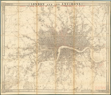
Attractive separately-issued folding map of London, issued by Carrington Bowles in 1792.
The map extends as far as Islington, Limehouse, Kennington, and Brompton. The densely built-up portion of London has not yet extended far beyond Mayfair in the west and the Tower in the east. The City of London is outline in original red hand-coloring.
The map names almost all streets, even the very small ones. Most of Belgravia and Chelsea are open fields.
Howgego (181) says the map was first issued in 1786, and the final issue came in 1814. There were at least 14 states of the map published during its run.
Condition Description
Original hand-color. Folding map dissected and mounted on original linen. Original marbled paper case with original label dated 1793 (worn). Separations to linen mainly at fold intersections.
Reference
Howgego 181, state 5 (of 14)
![[ London ] A New and Correct Plan of the Cities and Suburbs of London & Westminster Borough of Southwark with the Country adjacent the New Buildings Roads](https://storage.googleapis.com/raremaps/img/small/102623.jpg)
![[A View of the West Side of London Bridge in the Year 1710, from an Engraving by Sutton Nicholls]](https://storage.googleapis.com/raremaps/img/small/86990.jpg)