|
||

|

|
|

|
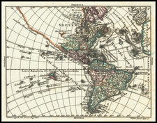
Rare early map of America, the second earliest map of America published in Paris to show California as an island, after Pierre Mariette's rare re-issue of the Danckerts Wall Map of America.
The map Pre-dates the earliest of the Sanson maps, relying upon a modified version of Briggs.
Like Sanson, Briet was born in Abbeville and became a Jesuit at age 18. His Parallela Geographiae was both a modern and classical geographical work. As the title indicates, the map divides the coastlines between the spheres of influence. It is noteworthy that Briet claims the Chesapeake and everything to the North for France, ignoring the English claims to New England. Unusual projection for South America. One of the rarest of the obtainable early maps of California as an island.
![Suite Du Bresil . . . [2 maps]](https://storage.googleapis.com/raremaps/img/small/103662.jpg)
![La America Dispuesta segun las ultimas y nuevas observationes de las Accademias, y de Paris, y de Londres [Bay or Sea of the West--Very Rare]](https://storage.googleapis.com/raremaps/img/small/75936.jpg)