|
||

|

|
|

|
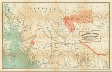
First Map of the Province of British Columbia -- Colored To Delineate 1871 Federal Election Districts!
The First Map of the the Province of British Columbia, produced by its most important early mapmaker and Lieutenant Governor and and colored to show the election districts for the first elections in the province.
Trutch's map is the first map of the new province, an exceptionally detailed summary of the geographical knowledge of the region in 1871. Trutch draws upon the work of John Palliser (1857-61) and numerous surveys in the 1860s by British Royal Engineers, following its becoming a colony in 1858. The Cariboo goldfields are shown, incorporating the results of one of Canada's earliest gold rush, which compelled the creation of some of the earliest infrastructure and roads in the interior of the region. The coastal and hydrographical details along the coast are drawn from British Admiralty surveys, most notably those of Captain George Henry Richards, (1858-1859). The map would remain the baseline map and gold standard for the mapping of the region for several decades.
The present example of the map is of particular interest for its primitive hand drawn delineation of the Yale District, Cariboo District, New Westminster District, Lillooet District, and Kootenai District, representing one of the earliest surviving depictions of the first Federal Election Districts in British Columbia. These districts illustrate 5 of the 12 electoral districts in British Columbia's first election, with the remaining 7 districts being far more densely populated parts of Vancouver or Vancouver Island. As noted in Electoral History of British Columbia, 1871-1986:
British Columbia became a province and entered Confederation 20 July 1871. An interim Cabinet was appointed by the Lieutenant-Governor and election writs were issued to choose 25 Members from 12 Electoral Districts for the first provincial Legislature. The general election was held from October through December 1871 and was conducted by means of a show of hands on nomination day and, if required, an open poll book on polling day. There were 46 candidates and no organized political parties. No election deposit was required. There were less than 3000 registered voters who qualified by being male British subjects, 21 years of age, who met certain property and residence requirements.
The following are the 12 districts
- Cariboo (three members)
- Comox (Vancouver Island)
- Cowichan (two members) (Vancouver Island)
- Esquimalt (two members) (Vancouver Island)
- Kootenay (two members)
- Lillooet (two members)
- Nanaimo (Vancouver Island)
- New Westminster (two members)
- New Westminster City (Vancouver)
- Victoria (two members) (Vancouver Island)
- Victoria City (four members) (Vancouver Island)
- Yale (three members)
Joseph William Trutch
Sir Joseph William Trutch was an English-born Canadian engineer, surveyor and politician. Trutch worked together with British Columbia's colonial governor, Anthony Musgrave to lay the foundation for its entry into the recently created Canadian Confederation, which was first created in 1867. In 1870, Trutch was part of the delegation which negotiated the terms of union with the Canadian Confederation and a promise ,for the construction of the Canadian Pacific Railway (CPR). While in London, he also contracted with Edward Standford to print 500 copies of his map of British Columbia (known as the 1871 Trutch Map).
Trutch was the first Lieutenant Governor of British Columbia following Confederation, a position he retained from 1871-1876. Following his tenure as lieutenant governor, Trutch was appointed a "Dominion agent for British Columbia", and helped to oversee the construction of the CPR in the province.
On July 20, 1871, British Columbia became the sixth province to join Canada. In return for entering the Confederation, Canada absorbed British Columbia's debts and committed to the construction of a rail route from Montreal to the Pacific Ocean within a decade, thereby bringing to a close a period of uncertainty in which the residents of British Columbia also debated joining the United States or remaining a British Colony separate from Canada.
The last spike of the Canadian Pacific Railway would not be driven until 1886, but its completion would ultimately result in a boom in the population of British Columbia that soon saw it become Canada's largest province.
States of the Map
The map is scarce on the market, almost always found segmented and laid on linen, in a folding cover.
A few examples survive which were likely issued for government purposes and were annotated in early times for official usage (see for example the copy at Boston Public Library, annotated to show Post Offices).
The example of this map at the British National Archives (Kew) notes the inclusion of "Coloured manuscript additions highlight boundaries etc.," which matches general color and manuscript additions present here, suggesting that the present example was likely created for official use.
The University of British Columbia holds a proof copy of the map. "This map is blank where the title block should be, and lacks the scale statement, and the imprint. "Outline and writing by Charles Kersting" written in left margin. Verso: ms. note "A proof copy of the Trutch map of 1871.""
![[British Columbia] Map of the South-Western Part of British Columbia Compiled and Drawn By Direction of the Honorable R.F. Green, Chief Commissioner of Lands and Works Victoria, B.C. 1906](https://storage.googleapis.com/raremaps/img/small/63681.jpg)
![[Havana / Cartagena] Neu und Verbesserter Plan der St. u. Hafens Havana aus der Ins. Cuba . . . 1739 [with] Neu under verbesserter lan des Hafnes non Cathaagena in America . . . 1740](https://storage.googleapis.com/raremaps/img/small/89441.jpg)