


|
||

|

|
|

|
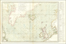
Charting the Triangular Trade After the Seven Years War
Finely executed sea chart of the northern Atlantic Ocean, published by the Depot de la Marine, under the direction of Nicolas Bellin.
Published shortly after the end of the Seven Years (or French & Indian) War, the chart covers the area which includes the so-called Triangular Trade which operated between the Slave Trading ports of West Africa, the Caribbean and east coast of North America, and the British and French ports of the Atlantic Coast.
The Depot de la Marine was by the mid-18th Century the most prolific publisher of sea charts of all parts of the world, eclipsing the Dutch as the greatest mapmakers of the Oceans of the World.
Includes two large, decorative cartouches. This is the fourth updated edition of a map originally produced in 1738 for the Ministre de la Marine.
Jacques-Nicolas Bellin (1703-1772) was among the most important mapmakers of the eighteenth century. In 1721, at only the age of 18, he was appointed Hydrographer to the French Navy. In August 1741, he became the first Ingénieur de la Marine of the Dépôt des cartes et plans de la Marine (the French Hydrographic Office) and was named Official Hydrographer of the French King.
During his term as Official Hydrographer, the Dépôt was the one of the most active centers for the production of sea charts and maps in Europe. Their output included a folio-format sea atlas of France, the Neptune Francois. He also produced a number of sea atlases of the world, including the Atlas Maritime and the Hydrographie Francaise. These gained fame and distinction all over Europe and were republished throughout the eighteenth and even in the nineteenth century.
Bellin also produced smaller format maps such as the 1764 Petit Atlas Maritime, containing 580 finely-detailed charts. He also contributed a number of maps for the 15-volume Histoire Generale des Voyages of Antoine François Prévost.
Bellin set a very high standard of workmanship and accuracy, cementing France's leading role in European cartography and geography during this period. Many of his maps were copied by other mapmakers across the continent.
![Tabula Terre Nove [The Admiral's Map]](https://storage.googleapis.com/raremaps/img/small/81714.jpg)
![[St. Helena] Vera effigies et delineatio Insulae Sanctae Helenae qua Ortum Occasium, et Septentrionem spectat . . . / The true description, and Scituation of the Island of St. Helena on the East, North and West Sydes, lyuning under 16. degrees on the Southsyde of the Equinoxiall line.](https://storage.googleapis.com/raremaps/img/small/69465.jpg)