


|
||

|

|
|

|
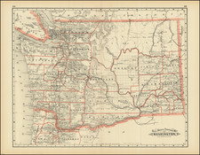
The Best Map of Western Washington From the 19th Century
Rare large format map of the western part of Washington Territory, the earliest separately issued large format map of Washington Territory.
The map is colored by counties and highlights the rugged topography of the western part of the Washington Territory at the beginning of its boom years. Seattle is a tiny settlement south of Union Lake, with a "Saw Mill" noted across Elliott Bay and Alki Point.
Tacoma is shown as an even smaller town, with a neighboring saw mill, 3 years before it was selected as the terminus of the Northern Pacific Railroad (over Seattle). This is the first appearance of Tacoma on a map, then just a five-block plat surveyed by pioneer Anthony P. Carr and filed in November 1869.
The map includes extensive soundings and coastal features, beginning in the Strait of San Juan de Fuca. San Juan Island is named, with an area of Prairie land identified in green. Ft. Bellingham, Whatcom and the Coal mines at the mouth of the Whatcom River are shown. Near Port Townsend, Marrowstone Island is also alternatively identified as Pt. Ringgold, named for Captain Cadwalader Ringgold, a crew member aboard the Wilkes expedition who would go on to create the first set of Sea Charts of the area around San Francisco Bay in 1850.
According to text on the map, Colton based this early commercial map of Washington Territory on U.S. surveys by Charles A. White. White's map is a masterwork of topographical detail, at a time when no other map of Washington had been attempted on such a large scale. The extent of the General Land Office Township Surveys can be seen, along with towns, roads, forts, rivers, Government Reserves, Indian Reservations and a host of other cartographic details.
The color code denotes:
- Prairie Lands (Green)
- Government Reserves (Red)
- Indian Reservations (Blue)
The Library of Congress catalog entry attribute the map to Charles Abiathar White (1826-1910), the U.S. geologist who served as state geologist of Iowa and later participated in U.S. Geological Surveys in the West.
States of the map and Rarity
States of the map:
- State 1: Predating the Copyright of Hazard Stevens (an Olympia bookseller, who later advertised the map for sale).
- State 2: Copyright of Hazard Stevens added below the scale of miles at bottom left. Includes several other corrections, including the removal of Quillehuyte County, which existed as a county for about 1 year between 1868 and 1869. The county boundaries are also corrected pursuant to the Legislative Act approved on December 2, 1869.
The map is rare on the market.

![[Oregon Territory] Carte de l'Oregon (and) [Astoria Factory]](https://storage.googleapis.com/raremaps/img/small/77722.jpg)

![Map of Oregon, Washington and Part of Idaho [First Appearance Of Idaho Territory, including western Montana and Western Wyoming]](https://storage.googleapis.com/raremaps/img/small/94211.jpg)