|
||

|

|
|

|
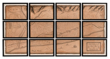
The First Published Map to Show Pebble Beach with Development, Lots, and Proposed Golf Links
This map provides a sweeping view from the south that focuses on the stunning portion of the Monterey Peninsula between Cypress Point and Promontory Point now known as Pebble Beach.
The area around Pebble Beach, with golf links that are only just being proposed in this map, is visible in the foreground. The as-yet undeveloped areas of the Monterey Peninsula, including Del Monte, are shown with crisscrossing forest roads including the famous "Seventeen Mile Drive." Further to the north, Monterey and Pacific Grove can be identified. The location of the once-famous "ostrich tree" is shown, as is Cypress Point. This work is the first publicly printed map we have found to reference a golf course in the Pebble Beach area, as well as to show the newly constructed Pebble Beach Lodge.
Pebble Beach History
This map was published by the Pacific Improvement Company in order to advertise its holdings in the Pebble Beach area. Pacific Improvement was a subsidiary of the South Pacific Railroad that had opened a hotel in the Del Monte area in 1880. It was only beginning to draw investment farther south in the early 1900s. The first tolls for Seventeen Mile Road were collected in 1901, and the company first announced a resort in the Pebble Beach area in 1907. Pebble Beach Lodge would open to cater to daytrippers from the Del Monte Hotel in 1909, the same year that this map was published.
This is one of the earliest published references to a golf course in the area, despite the classic misunderstanding that Samuel Morse (a relative of the inventor of the telegraph) would be responsible for being the first to propose a golf course at Pebble Beach. However, Morse did not join the Pacific Improvement Company until 1915. Instead, this map shows that plans for a golf course in the area were thought out and advertised even before the lodge opened. Morse would succeed in establishing the Pebble Beach Co. in 1919, then known as the Del Monte Properties Company).
The sale of the lots of the lots shown on the map would start in 1909 with further subdivisions made in the coming years. However, Morse would buy back some of the properties that had already been sold in order to ensure sufficient greenspace
The targets of this advertisement are decidedly upper class, with certain lines stating that "no residence shall be erected at a cost of less than $1500" and that "prices range from $250 to $2500 an acre [sic]." Interesting information is provided that details the extent of the Pacific Improvement Company's ambitions in the area, and provides many insights into the development of the Del Monte peninsula.
In all, this is a rare and important early modern map of the Pebble Beach area.
Rarity
No copies in OCLC. An example is held by the Pebble Beach Golf Course.
![[Section of Newport Beach]](https://storage.googleapis.com/raremaps/img/small/33577df.jpg)
![[Southern California Views] Delightful Southern California, The Land of Sunshine and Bloom](https://storage.googleapis.com/raremaps/img/small/74862.jpg)
![The Monterey Peninsula California Pinto Guide Map to Fine Accommodations Restaurants Theatres Services Shops [double sided map]](https://storage.googleapis.com/raremaps/img/small/102769.jpg)