|
||

|

|
|

|
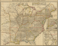
Marvelous highly detailed map of the United States from Hall's New General Atlas. The map provides are remarkable snapshot of the US in the midwest, old Northwest Territory, and the Plains, along with an early inset of Oregon Territory, with a 54-40 or fight border with British America, which Wheat notes as being quite eccentric for and English map. Massive double wide Arkansa Territory is shown. NW Territory is confined to Wisconsin, the Upper Peninsula of Michiganand part of Minnesota. Indian Tribes dominate what would become Minnesota, Iowa and Dacotah. The map shows Missouri Territory extending nearly to the Rocky Mountains., with excellent treatment of the Missouri River and its upper tributaries, extending west to Yellowstone River Many unusual Indian Tribes named in Montana and Wyoming, including the Castahana, Nemou, Yepe, Keeheetsa, Dotames, Shieynne or Sharhas, Staetans or Kites, Ricarees, Mandans, Minatarees and others. The large inset of the Continuation of The Western Territory is based upon Lewis & Clark, extending from Big Horn, Clark's Fork and Yellowstone River in the east to Queen Charlotte's Sound and the Columbia and Mutinomah Rivers in the West. The Canoe Camp, Mt. Ranier, Mt. Hood and Mt. St Helens are shown. In the north, the are forts, Indian Villages and other details. A number of disputed boundaries with British America are shown. Excellent detail throughout. Wheat 381.
![[ Promoting Emigration To The Czech Market ] Ceske Osady V Americe [ A Correct Map of the United States of America Showing Atchison, Topeka and Santa Fe R.R. and Connections ]](https://storage.googleapis.com/raremaps/img/small/101348.jpg)
![[Uncut promotional broadsides for ] Map of the Surface-Feeding Ducks, Swans and Geese of North America](https://storage.googleapis.com/raremaps/img/small/92052.jpg)