|
||

|

|
|

|
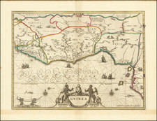
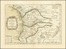
Important Slave Trade Post
Rare early Dutch map of a portion the area around Elmina Castle, published by Johannes Blaeu in 1647.
Elmina Castle was erected by the Portuguese in 1482 as Castelo de São Jorge da Mina (St. George of the Mine Castle), also known as Castelo da Mina or simply Mina, in present-day Elmina, Ghana (formerly the Gold Coast).
The castle was the first trading post built on the Gulf of Guinea, and the oldest European building in existence south of the Sahara. First established as a trade settlement, the castle later became one of the most important stops on the route of the Atlantic slave trade. The Dutch seized the fort from the Portuguese in 1637 and took over all of the Portuguese Gold Coast in 1642. The slave trade continued under the Dutch until 1814. In 1872, the Dutch Gold Coast, including the fort, became a possession of Great Britain.
Joan, or Johannes, Blaeu (1596-1673) was the son of Willem Janszoon Blaeu. He inherited his father’s meticulous and striking mapmaking style and continued the Blaeu workshop until it burned in 1672. Initially, Joan trained as a lawyer, but he decided to join his father’s business rather than practice.
After his father’s death in 1638, Joan and his brother, Cornelis, took over their father’s shop and Joan took on his work as hydrographer to the Dutch East India Company. Joan brought out many important works, including Nova et Accuratissima Terrarum Orbis Tabula, a world map to commemorate the Peace of Westphalia which brought news of Abel Tasman’s voyages in the Pacific to the attention of Europe. This map was used as a template for the world map set in the floor of the Amsterdam Town Hall, the Groote Burger-Zaal, in 1655.
Joan also modified and greatly expanded his father’s Atlas novus, first published in 1635. All the while, Joan was honing his own atlas. He published the Atlas maior between 1662 and 1672. It is one of the most sought-after atlases by collectors and institutions today due to the attention to the detail, quality, and beauty of the maps. He is also known for his town plans and wall maps of the continents. Joan’s productivity slammed to a halt in 1672, when a fire completely destroyed his workshop and stock. Joan died a year later and is buried in the Westerkerk in Amsterdam.
Georg Marcgraff (1610-1644) was a German astronomer and naturalist. In 1637, he was appointed astronomer of a company being formed to sail to the Dutch colony in Brazil. He accompanied Willem Piso, a physician and the newly appointed governor of the Dutch possessions in that country. Later, Marcgraf worked for Johannes Maruitiius of Nassau, who allowed Marcgraf to explore and later mapa considerable part of Brazil. He arrived in Brazil in early 1638 and undertook the first zoological, botanical, and astronomical expedition there, exploring various parts of the colony to study its natural history and geography. He later explored the coast of Guinea, where he died in 1644
During his time in Brazil, Marcgraf and Cornelis Goliath created a map of Brazil, under the sponsorship of Johan Maurits, which was completed in 1643. This map remained the most important ad accurate cartographic representation of Brazil until the 19th century. The Marcgraf Map—actually a series of maps—is illustrated with engravings that offer panoramas of Brazilian life. The illustrations in the map were probably based directly on the drawings of Frans Post, during his 7 years in Brazil as part of the Dutch occupation of the region.
![[ Sierra Leone to Côte d'Ivoire ] Pas-caert vande Gryen-Cust en Adaows Qua Quaas Tuhessen de Serraliones en C. de Tres Puntas . . . .](https://storage.googleapis.com/raremaps/img/small/99332.jpg)