The item illustrated and described below is sold, but we
have another example in stock. To view the example which
is currently being offered for sale, click the
"View Details" button below.


|
||

|

|
|

|
Stock# 7260
Description
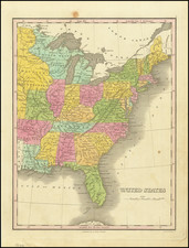
Detailed map of the United States and Canada. No West Viriginia shown. The Upper Peninsula is part of Wisconsin. A number of Indian Tribes are shown. Major cities, rivers, islands, bays, lakes, gulfs, mountains, etc. are shown. Includes decorative embellishments above the map and in the border. G.F. Cruchley was a mapseller and globemaker on Fleet Street in London in the mid-19th Century. His World Atlas, first published in 1854, was very unique for the period, employing vivid imagery and a striking print style, along with very distinctive coloring. Maps from his world atlas are relatively scarce on the market.
![United States of America [with] The Course of the River St. Laurence from Lake Ontarion to Manicouagan Point](https://storage.googleapis.com/raremaps/img/small/71643.jpg)
![[Signed Political Satire Artwork] Vietnam ... Vietnam ... Vietnam ...](https://storage.googleapis.com/raremaps/img/small/68726.jpg)
![[French America and the Triangular Trade] L'Amérique Françoise Où son Décrites La France Nouvelle, La France Insulaire, La France Equinoctiale, et autre pais Par P. Du Val d'Abbeville Geographe du Roy . . .](https://storage.googleapis.com/raremaps/img/small/91968.jpg)
![[United States] Etats-Unis](https://storage.googleapis.com/raremaps/img/small/62774.jpg)