
This item has been sold, but you can enter your email address to be notified if another example becomes available.


|
||

|

|
|

|
Stock# 71193
Description
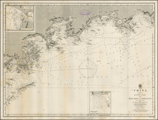
World War II-era hydrographical chart of the entrance to the Yangtze River and the Shanghai Region.
Shanghai is shown at the left of the map, with details such as the railroads and their stations, the International Settlements, and local hamlets and creeks all labeled.
Interestingly, Shanghai was under Japanese occupation in 1944, when this map was made, and it would remain so until the end of the war in 1945.
![[ Battle of Shanghai - Third Shanghai Expeditionary Force ] Shanghai and District 1936 Edition](https://storage.googleapis.com/raremaps/img/small/100559.jpg)
![[ Hong Kong, Canton & Environs ] Carte des Isles qui sont a L'Entree de la Riviere De Canton](https://storage.googleapis.com/raremaps/img/small/74493.jpg)