|
||

|

|
|

|
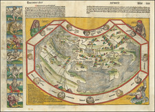
"This is the first known printed map to show the earth as a sphere..." - Jaya Remond in Prints and the Pursuit of Knowledge in Early Modern Europe.
A fine example of the Albrecht Durer and Johannes Stabius's famous woodblock world map, the first printed perspective projection of a terrestrial hemisphere.
Although not signed, this striking world map is acknowledged to be the work of Albrecht Dürer. The map was produced in collaboration with Johann Stabius, astronomer to the court of Maximilian I, and was issued with a pair of celestial charts on which Durer and Stabius had collaborated. The spherical world is surrounded by spectacular depictions of the twelve traditional windheads, with the corners bearing (clockwise from the upper left) the arms of Cardinal Matthaüs Lang, Archbishop of Salzburg, Stabius's dedication to Cardinal Lang, the privilege granted to Stabius by Maximilian dated 1515, and the arms of Stabius .Of the artistic elements in the woodcut, the windheads (a holdover from Ptolemy), are particularly redolent of Durer's virtuosity and fantastical imagination.
No sixteenth-century example of the map survives, but the original woodblocks were rediscovered shortly before the present impressions were pulled in 1781. This edition, published by Joseph Elden von Kurzbeck under the supervision of the scholar Johann Adam von Bartsch, is itself now very rare. The woodblocks are now preserved in the Albertina Museum.
The cartography is the work of Johannes Stabius, the court mathematician to Emperor Maximilian I, and is largely based on Martin Behaim's 1492 globe, a cartographic landmark in its own right.
Creating the illusion of three-dimensionality in the rendering of a globe was no small feat in 1515, and the map is a landmark in artistic perspective.
"The most interesting features of the map are those with which we must suppose Dürer endowed it: the vigorous artistic presentation and the ingenious representation of a globular map upon a flat surface—one of the earliest stereographic projections attempted" (World Encompassed).
Cartography
Durer and Stabius's choice of focus for the map, directly over the Persian Gulf, bears examining; it renders marginal areas that might have been of great interest to the intended viewers, namely Europe and, in the first decades of the 16th century, the Americas. When comparing the map with Martin Behaim's globe it is clear that the perspective was carefully chosen to maximize the geography from that globe that could be shown on a two-dimensional surface. One can imagine Stabius and Durer sitting in front of the globe, manipulating its angles to frame the best perspective for the map. Indeed, Shirley speculated that the composition of the map image might have been a largely academic exercise.
The map is sometimes said to be largely based on Ptolemy. This is generally true, though the map is based on Ptolemy insofar as it is based on Behaim's globe, from which all the major outlines derive. Some changes have been made, in particular to toponyms, that establish the maker as more than just a slavish copyist, but someone who was reasonably well-read in geographical matters.
The map includes the following block of text in Latin in the upper right corner:
Reverendiss. domino et illustriss. Principi Dño. Matheo. T Angeli Diacono Cardinali Gurceñ: Sa. Caẽs. Mtis per Italia locũtenenti generali vdño suo colen. Joañ Stabius Au. hãc orb imaginem dedicat
In the lower right is another text block:
Imp Caes niuus Maximilianus P.F. Aug. Privilegio caiut nequis Libros, membraenas, cartas, pictu'as volumĩa. vel quecuqe alia que Ioan, Stabius Au. sub suo titulo & nomie emiserit sine sua expressa voluntate In decem annis a die editioĩs sequentibus imprimat sub pena amissionis rerum impressarum & decem mâcharum auri puri. 1.5.1.5.
Rarity and States
1515: No examples from the 16th century are known to exist.
1781: Printed by Adam von Bartsch from the original woodblocks, which are now at the Albertina. Printed on laid paper watermarked with the Crest of Wolfegg. With the imprint: "Editum ex Tabula lignea ab Alberto Durer incisa, quae in Bibliotheca Aug. Vindob. extat. M. DCC. LXXXI."
1847: Printed by Ritter. Lacking the imprint text below the map.
![A General Atlas Containing Distinct Maps Of all the known Countries in the World. Constructed from the Latest Authority [Binder's title: Lucas's Cabinet Atlas]](https://storage.googleapis.com/raremaps/img/small/80266.jpg)
![[ World Map ] Карта Шара Земнаго Сочиненная по Астрономическимъ Наблюденїямъ. Жанверомъ. [Globular Map of the Earth Compiled from Astronomical Observations. Janvier]](https://storage.googleapis.com/raremaps/img/small/65900.jpg)